Carnegie railway station
Carnegie | ||||||||||||||||||||||||||||||||||||||||||||||||||||||||||||||||||||||
|---|---|---|---|---|---|---|---|---|---|---|---|---|---|---|---|---|---|---|---|---|---|---|---|---|---|---|---|---|---|---|---|---|---|---|---|---|---|---|---|---|---|---|---|---|---|---|---|---|---|---|---|---|---|---|---|---|---|---|---|---|---|---|---|---|---|---|---|---|---|---|
| PTV commuter rail station | ||||||||||||||||||||||||||||||||||||||||||||||||||||||||||||||||||||||
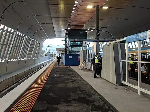 South-east bound view from Platform 2, June 2018 | ||||||||||||||||||||||||||||||||||||||||||||||||||||||||||||||||||||||
| General information | ||||||||||||||||||||||||||||||||||||||||||||||||||||||||||||||||||||||
| Location | Morton Avenue, Carnegie, Victoria 3163 City of Glen Eira Australia | |||||||||||||||||||||||||||||||||||||||||||||||||||||||||||||||||||||
| Coordinates | 37°53′11″S 145°03′31″E / 37.8863°S 145.0585°E | |||||||||||||||||||||||||||||||||||||||||||||||||||||||||||||||||||||
| Owned by | VicTrack | |||||||||||||||||||||||||||||||||||||||||||||||||||||||||||||||||||||
| Operated by | Metro Trains | |||||||||||||||||||||||||||||||||||||||||||||||||||||||||||||||||||||
| Line(s) | ||||||||||||||||||||||||||||||||||||||||||||||||||||||||||||||||||||||
| Distance | 13.53 kilometres from Southern Cross | |||||||||||||||||||||||||||||||||||||||||||||||||||||||||||||||||||||
| Platforms | 2 (1 island) | |||||||||||||||||||||||||||||||||||||||||||||||||||||||||||||||||||||
| Tracks | 2 | |||||||||||||||||||||||||||||||||||||||||||||||||||||||||||||||||||||
| Connections |  Bus | |||||||||||||||||||||||||||||||||||||||||||||||||||||||||||||||||||||
| Construction | ||||||||||||||||||||||||||||||||||||||||||||||||||||||||||||||||||||||
| Structure type | Elevated | |||||||||||||||||||||||||||||||||||||||||||||||||||||||||||||||||||||
| Parking | 120 spaces | |||||||||||||||||||||||||||||||||||||||||||||||||||||||||||||||||||||
| Bicycle facilities | Yes | |||||||||||||||||||||||||||||||||||||||||||||||||||||||||||||||||||||
| Other information | ||||||||||||||||||||||||||||||||||||||||||||||||||||||||||||||||||||||
| Status | Operational, premium station | |||||||||||||||||||||||||||||||||||||||||||||||||||||||||||||||||||||
| Station code | CNE | |||||||||||||||||||||||||||||||||||||||||||||||||||||||||||||||||||||
| Fare zone | Myki Zone 1 | |||||||||||||||||||||||||||||||||||||||||||||||||||||||||||||||||||||
| Website | Public Transport Victoria | |||||||||||||||||||||||||||||||||||||||||||||||||||||||||||||||||||||
| History | ||||||||||||||||||||||||||||||||||||||||||||||||||||||||||||||||||||||
| Opened | 2 April 1879 | |||||||||||||||||||||||||||||||||||||||||||||||||||||||||||||||||||||
| Rebuilt | 18 June 2018 (LXRP) | |||||||||||||||||||||||||||||||||||||||||||||||||||||||||||||||||||||
| Electrified | March 1922 (1500 V DC overhead) | |||||||||||||||||||||||||||||||||||||||||||||||||||||||||||||||||||||
| Previous names | Rosstown (1879–1909) | |||||||||||||||||||||||||||||||||||||||||||||||||||||||||||||||||||||
| Passengers | ||||||||||||||||||||||||||||||||||||||||||||||||||||||||||||||||||||||
| Passengers (2005–2006) | 613,043[1] | |||||||||||||||||||||||||||||||||||||||||||||||||||||||||||||||||||||
| Passengers (2006–2007) | 667,653[1]  8.9% | |||||||||||||||||||||||||||||||||||||||||||||||||||||||||||||||||||||
| Passengers (2007–2008) | 746,242[1] 11.77% | |||||||||||||||||||||||||||||||||||||||||||||||||||||||||||||||||||||
| Passengers (2008–2009) | 831,026[2] 11.36% | |||||||||||||||||||||||||||||||||||||||||||||||||||||||||||||||||||||
| Passengers (2009–2010) | 860,100[2] 3.49% | |||||||||||||||||||||||||||||||||||||||||||||||||||||||||||||||||||||
| Passengers (2010–2011) | 894,113[2] 3.95% | |||||||||||||||||||||||||||||||||||||||||||||||||||||||||||||||||||||
| Passengers (2011–2012) | 829,079[2]  7.27% | |||||||||||||||||||||||||||||||||||||||||||||||||||||||||||||||||||||
| Passengers (2012–2013) | Not measured[2] | |||||||||||||||||||||||||||||||||||||||||||||||||||||||||||||||||||||
| Passengers (2013–2014) | 950,645[2] 14.66% | |||||||||||||||||||||||||||||||||||||||||||||||||||||||||||||||||||||
| Passengers (2014–2015) | 1,010,382[1] 6.28% | |||||||||||||||||||||||||||||||||||||||||||||||||||||||||||||||||||||
| Passengers (2015–2016) | 1,217,932[2] 20.54% | |||||||||||||||||||||||||||||||||||||||||||||||||||||||||||||||||||||
| Passengers (2016–2017) | 910,282[2] 25.26% | |||||||||||||||||||||||||||||||||||||||||||||||||||||||||||||||||||||
| Passengers (2017–2018) | 764,922[2] 15.96% | |||||||||||||||||||||||||||||||||||||||||||||||||||||||||||||||||||||
| Passengers (2018–2019) | 991,272[2] 29.59% | |||||||||||||||||||||||||||||||||||||||||||||||||||||||||||||||||||||
| Passengers (2019–2020) | 833,000[2] 15.96% | |||||||||||||||||||||||||||||||||||||||||||||||||||||||||||||||||||||
| Passengers (2020–2021) | 460,850[2] 44.67% | |||||||||||||||||||||||||||||||||||||||||||||||||||||||||||||||||||||
| Passengers (2021–2022) | 510,850[3] 10.85% | |||||||||||||||||||||||||||||||||||||||||||||||||||||||||||||||||||||
| Services | ||||||||||||||||||||||||||||||||||||||||||||||||||||||||||||||||||||||
| ||||||||||||||||||||||||||||||||||||||||||||||||||||||||||||||||||||||
| ||||||||||||||||||||||||||||||||||||||||||||||||||||||||||||||||||||||


Carnegie is a train station on the Cranbourne and Pakenham line. This station and its lines are part of the Melbourne train network, controlled by Metro Trains Melbourne.[4] It serves the suburb of the same name, in southeastern Melbourne, Victoria, Australia.[4] Carnegie is an elevated premium station. This means the station is on a railway viaduct (skyrail).
Carnegie has a concourse on Koornang Road and you can go to the platforms from escalators, lifts and stairs.[4]
History
Carnegie station first opened on 2 April 1879. Carnegie station was named after Andrew Carnegie.[5] But it wasn't always that way, the original name was Rosstown, after William Ross. But his poorly built railway line and housing estate failed and soon after he died. The Rosstown railway closed, the houses never went ahead and furthermore his sugar factory was demolished. The name "Rosstown" went very unpopular.[6] People living there changed the station and suburb name to Carnegie.
In March 2014, the Level Crossing Removal Project announced that the Koornang Road level crossing west of Carnegie station was closing. On 18 June 2018, Carnegie was opened as a skyrail station, and the level crossing was pulled down.[7]
Platforms
Carnegie station has one island platform with two faces. Carnegie serves Pakenham and Cranbourne trains. Services to East Pakenham and Cranbourne go southeast towards Dandenong before splitting up. Services to the city run express to Anzac from Malvern and continues to Sunbury station.
| Carnegie platform arrangement | ||||
|---|---|---|---|---|
| Platform | Line | Where to? | Using | Stopping Pattern |
| 1 | Cranbourne line Pakenham line |
Sunbury, Watergardens, West Footscray | Town Hall | Limited express trains: Trains not stopping at Armadale to Hawksburn. |
| 2 | Cranbourne line Pakenham line |
East Pakenham, Cranbourne, Westall | Trains stop all stations. | |
Transport links
Carnegie has four bus routes. The 623 from Glen Waverley to St Kilda and the 626 to Middle Brighton to Chadstone Shopping Centre go from Koorang Road.
Meanwhile the 624 Kew to Oakleigh station stops from Neerim Road, and the Princes Highway has the SmartBus 900 from Stud Park Shopping Centre in Rowville to Caulfield station.
References
- 1 2 3 4 Estimated Annual Patronage by Network Segment Financial Year 2005–2006 to 2018–19 Archived 17 April 2022 at the Wayback Machine Department of Transport
- 1 2 3 4 5 6 7 8 9 10 11 12 Railway station and tram stop patronage in Victoria for 2008–2021 Archived 17 December 2022 at the Wayback Machine Philip Mallis
- ↑ Annual metropolitan train station patronage (station entries) Archived 6 March 2023 at the Wayback Machine Data Vic
- 1 2 3 "Carnegie". Metro Trains Melbourne. Archived from the original on 1 April 2023. Retrieved 17 May 2023.
- ↑ Anderson, Rick (2010). Stopping all stations : Melbourne's unfinished rail network/opportunities lost. Clunes, Victoria.
{{cite book}}: CS1 maint: location missing publisher (link) - ↑ "Carnegie". Victorian Places. Archived from the original on 12 December 2022. Retrieved 21 January 2023.
- ↑ "Every Caulfield to Dandenong level crossing gone". Victoria's Big Build. 19 June 2018. Archived from the original on 5 May 2023. Retrieved 5 May 2023.
External links
- Melway map at street-directory.com.au