Westport, New Zealand
Westport
Kawatiri (Māori) | |
|---|---|
 | |
| Coordinates: 41°45′29″S 171°36′8″E / 41.75806°S 171.60222°E | |
| Country | New Zealand |
| Region | West Coast |
| District | Buller District |
| Ward | Westport |
| Electorates | |
| Government | |
| • Territorial Authority | Buller District Council |
| • Regional council | West Coast Regional Council |
| • Mayor of Buller | Chris Russell[1] |
| • West Coast-Tasman MP | Maureen Pugh |
| • Te Tai Tonga MP | Tākuta Ferris |
| Area | |
| • Total | 11.53 km2 (4.45 sq mi) |
| Population (June 2023)[3] | |
| • Total | 4,250 |
| • Density | 370/km2 (950/sq mi) |
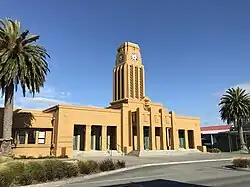
Westport is the main town in the Buller District, New Zealand. It is located on State Highway 67 and is close to the Buller River. It is situated north of Greymouth and southeast of Nelson. It has three primary schools and one high school located in the town. It thrives on coal mining.
References
- ↑ "2025 Triennial Elections Declaration of Result" (PDF). Electionz. Retrieved 17 October 2025.
- ↑ Cite error: The named reference
Areawas used but no text was provided for refs named (see the help page). - ↑ "Subnational population estimates (RC, SA2), by age and sex, at 30 June 1996-2023 (2023 boundaries)". Statistics New Zealand. Retrieved 25 October 2023. (regional councils); "Subnational population estimates (TA, SA2), by age and sex, at 30 June 1996-2023 (2023 boundaries)". Statistics New Zealand. Retrieved 25 October 2023. (territorial authorities); "Subnational population estimates (urban rural), by age and sex, at 30 June 1996-2023 (2023 boundaries)". Statistics New Zealand. Retrieved 25 October 2023. (urban areas)