Karamea
Karamea | |
|---|---|
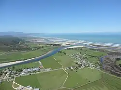 Market Cross, Karamea, and the Ōtūmahana Estuary | |
| Coordinates: 41°15′S 172°07′E / 41.250°S 172.117°E | |
| Country | New Zealand |
| Region | West Coast |
| District | Buller District |
| Ward | Seddon |
| Electorates | |
| Government | |
| • Territorial Authority | Buller District Council |
| • Regional council | West Coast Regional Council |
| • Mayor of Buller | Chris Russell[1] |
| • West Coast-Tasman MP | Maureen Pugh |
| • Te Tai Tonga MP | Tākuta Ferris |
| Area | |
| • Total | 66.08 km2 (25.51 sq mi) |
| Population (June 2023)[3] | |
| • Total | 410 |
| • Density | 6.2/km2 (16/sq mi) |
Karamea is an isolated town in the Buller District, New Zealand. It is situated 96 kilometers northeast of Westport and is the northmost town on the South Island West Coast. It has an area school (which is non-uniformed), library, museum, church and has a catchment area of the Karamea River.
References
- ↑ "2025 Triennial Elections Declaration of Result" (PDF). Electionz. Retrieved 17 October 2025.
- ↑ "ArcGIS Web Application". statsnz.maps.arcgis.com. Retrieved 23 May 2024.
- ↑ "Subnational population estimates (RC, SA2), by age and sex, at 30 June 1996-2023 (2023 boundaries)". Statistics New Zealand. Retrieved 25 October 2023. (regional councils); "Subnational population estimates (TA, SA2), by age and sex, at 30 June 1996-2023 (2023 boundaries)". Statistics New Zealand. Retrieved 25 October 2023. (territorial authorities); "Subnational population estimates (urban rural), by age and sex, at 30 June 1996-2023 (2023 boundaries)". Statistics New Zealand. Retrieved 25 October 2023. (urban areas)