Waimangaroa
Waimangaroa | |
|---|---|
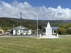 Denniston Road Scenic Reserve | |
| Coordinates: 41°42′46″S 171°45′46″E / 41.71278°S 171.76278°E | |
| Country | New Zealand |
| Region | West Coast |
| District | Buller District |
| Ward | Seddon |
| Electorates | |
| Government | |
| • Territorial Authority | Buller District Council |
| • Regional council | West Coast Regional Council |
| • Mayor of Buller | Chris Russell[1] |
| • West Coast-Tasman MP | Maureen Pugh |
| • Te Tai Tonga MP | Tākuta Ferris |
| Area .[2] | |
| • Total | 1.60 km2 (0.62 sq mi) |
| Population (June 2023)[3] | |
| • Total | 220 |
| • Density | 140/km2 (360/sq mi) |
Waimangaroa is a small town on the West Coast of New Zealand. It is located 17 kilometers north of Westport and 13 kilometers south-east of Granity. It had a primary school that ran until 2012 when it shut down with students going to Westport.
References
- ↑ "2025 Triennial Elections Declaration of Result" (PDF). Electionz. Retrieved 17 October 2025.
- ↑ "ArcGIS Web Application". statsnz.maps.arcgis.com. Retrieved 23 May 2024.
- ↑ "Subnational population estimates (RC, SA2), by age and sex, at 30 June 1996-2023 (2023 boundaries)". Statistics New Zealand. Retrieved 25 October 2023. (regional councils); "Subnational population estimates (TA, SA2), by age and sex, at 30 June 1996-2023 (2023 boundaries)". Statistics New Zealand. Retrieved 25 October 2023. (territorial authorities); "Subnational population estimates (urban rural), by age and sex, at 30 June 1996-2023 (2023 boundaries)". Statistics New Zealand. Retrieved 25 October 2023. (urban areas)