Investigator Strait
| Investigator Strait | |
|---|---|
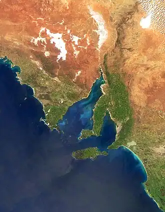 Investigator Strait is the body of water between Yorke Peninsula (i.e. the central land mass) and Kangaroo Island | |
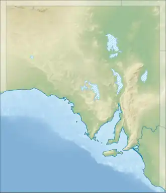  Investigator Strait | |
| Location | Australia |
| Coordinates | 35°24′S 137°36′E / 35.4°S 137.6°E |
| Basin countries | Australia |
| Max. length | 135.3 km (84.1 mi)[1] |
| Max. width | 48 km (30 mi)[1] |
| Surface area | 6,100 km2 (2,400 sq mi)[2] |
| Average depth | 34 m (112 ft)[2] |
| Max. depth | 75 m (246 ft)[2] |
| Islands | Althorpes Chinamans Hat Haystack Seal |
| Settlements | Marion Bay, Stenhouse Bay, Cape Jervis, Stokes Bay, Emu Bay |
Investigator Strait is a body of water (strait) in South Australia. It lies between Yorke Peninsula on the mainland and Kangaroo Island. Matthew Flinders named it after his ship, HMS Investigator, during his trip in 1801–1802. The strait is next to Gulf St Vincent in the northeast.
Discovery
Matthew Flinders named it Investigator’s Strait on March 29, 1802.[3]: 256
Location
Investigator Strait is north of Kangaroo Island and south of Yorke Peninsula. Flinders said its borders were Gulf St Vincent and Backstairs Passage. The border with Gulf St Vincent is a line from Troubridge Point on Yorke Peninsula to Cape Jervis on Fleurieu Peninsula.[2] The border with Backstairs Passage is from Cape Jervis to Kangaroo Head on Kangaroo Island. Flinders said Backstairs Passage is a different water area from Investigator Strait. The border between Investigator Strait and Nepean Bay on Kangaroo Island is between Point Marsden and Kangaroo Head. The western border of the strait is from Cape Spencer on Yorke Peninsula to Cape Borda on Kangaroo Island.
Protected areas
There are many protected parks and reserves in and near Investigator Strait:
Aquatic Reserves
- Troubridge Hill near Troubridge Point on Yorke Peninsula’s south coast.[4]
Marine Parks
- Southern Spencer Gulf Marine Park at the west end, covering coasts of Yorke Peninsula and Kangaroo Island.[5]
- Lower Yorke Peninsula Marine Park at the east end near Yorke Peninsula’s south coast.[6]
- Western Kangaroo Island Marine Park at the west end near Kangaroo Island’s north coast.[7]
- Encounter Marine Park at the east end, including borders with Nepean Bay and Backstairs Passage.[8]
National parks and other reserves on Yorke Peninsula’s south coast (west to east)
Reserves on Kangaroo Island’s north coast (west to east)
- Flinders Chase National Park[11]
- Cape Torrens Wilderness Protection Area[12]
- Western River Wilderness Protection Area[12]
Reserve on Althorpe Islands, Haystack Island, and Seal Island at the northwest end of the strait
- Althorpe Islands Conservation Park[13]
References
- 1 2 Hydrographic Department, Ministry of Defence (1983). Gulf of St Vincent and approaches (chart no. 1762). – reproduced by the Royal Australian Navy Hydrographic Service
- 1 2 3 4 Bye, J.A.T. (1976): Physical oceanography of Gulf St Vincent and Investigator Strait. In: Twidale, C.R., Tyler, M.J. & Webb, B.P. (Eds.), Natural history of the Adelaide Region. Royal Society of SA Inc, Adelaide. pp. 143.
- ↑ Flinders, Matthew (1966) [1814]. A Voyage to Terra Australis: Undertaken for the Purpose of Completing the Discovery of that Vast Country, and Prosecuted in the Years 1801, 1802, and 1803, in His Majesty's Ship the Investigator. Adelaide: Libraries Board of South Australia. LCCN 66070225. OCLC 4565366. OL 38607138M. Wikidata Q133875246.
- ↑ "Troubridge Hill Aquatic Reserve" (PDF). Primary Industries and Regions SA (PIRSA). Archived from the original (PDF) on 5 April 2015. Retrieved 19 June 2014.
- ↑ "Southern Spencer Gulf Park Management plan summary" (PDF). Department of Environment, Water and Natural Resources. p. 2 of 6. Retrieved 19 June 2014.
- ↑ "Lower Yorke Peninsula Marine Park summary" (PDF). Department of Environment, Water and Natural Resources. p. 2 of 6. Retrieved 19 June 2014.
- ↑ "Western Kangaroo Island Park Management plan summary" (PDF). Department of Environment, Water and Natural Resources. p. 27 of 29. Retrieved 23 June 2014.
- ↑ "Encounter Marine Park Management plan summary" (PDF). Department of Environment, Water and Natural Resources. p. 2 of 6. Retrieved 17 June 2014.
- ↑ "Innes National Park Management Plan" (PDF). Department for Environment and Heritage. 2003. p. 6. Retrieved 24 June 2014.
- ↑ "Mainland Conservation Parks of Yorke Peninsula Management Plan 2009" (PDF). Department for Environment and Heritage. p. 2. Retrieved 15 July 2014.
- ↑ "Flinders Chase National Park, Kelly Hill Conservation Park, Ravine des Casoars Wilderness Protection Area and Cape Bouguer Wilderness Protection Area Management Plans" (PDF). Department for Environment, Heritage and Aboriginal Affairs. 1999. p. 5. Retrieved 1 May 2014.
- 1 2 "Cape Torrens and Western River Wilderness Protection Areas Management Plan 2006" (PDF). Department for Environment and Heritage. p. 2. Retrieved 15 July 2014.
- ↑ Management Plan - Althorpe Islands, Goose Island and Troubridge Island Conservation Parks (PDF). Adelaide: Department of Environment & Heritage. 2009. pp. 1, 2 & 4. ISBN 978-1-921466-76-2.