Te Kūiti
Te Kūiti | |
|---|---|
Minor urban area | |
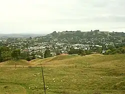 Te Kūiti viewed from the south-west as SH3 climbs out of the town. | |
| Coordinates: 38°20′S 175°10′E / 38.333°S 175.167°E | |
| Country | New Zealand |
| Region | Waikato region |
| District | Waitomo District |
| Ward | Te Kuiti Ward |
| Electorates | |
| Government | |
| • Territorial Authority | Waitomo District Council |
| • Regional council | Waikato Regional Council |
| Area | |
| • Total | 8.41 km2 (3.25 sq mi) |
| Population (June 2023)[2] | |
| • Total | 4,680 |
| • Density | 560/km2 (1,400/sq mi) |
| Postcode(s) | 3910 |
Te Kūiti is a town in the northern part of the King Country in New Zealand. It is located approximately 80 kilometers south of Hamilton and 19 kilometers south of Ōtorohanga on State Highway 3 and State Highway 30. There are four primary schools and one high school in the town. It is the home of the famous All Blacks rugby union player Colin Meads.
References
- ↑ "Stats NZ Geographic Data Service". Urban Rural 2023 (generalised). Retrieved 8 May 2025.
- ↑ "Subnational population estimates (RC, SA2), by age and sex, at 30 June 1996-2023 (2023 boundaries)". Statistics New Zealand. Retrieved 25 October 2023. (regional councils); "Subnational population estimates (TA, SA2), by age and sex, at 30 June 1996-2023 (2023 boundaries)". Statistics New Zealand. Retrieved 25 October 2023. (territorial authorities); "Subnational population estimates (urban rural), by age and sex, at 30 June 1996-2023 (2023 boundaries)". Statistics New Zealand. Retrieved 25 October 2023. (urban areas)