Ōtorohanga
Ōtorohanga | |
|---|---|
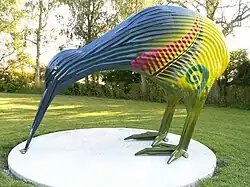 Corrugated iron sculpture of a kiwi in Ōtorohanga | |
| Coordinates: 38°11′S 175°12′E / 38.183°S 175.200°E | |
| Country | New Zealand |
| Region | Waikato region |
| District | Ōtorohanga District |
| Ward | Ōtorohanga Ward |
| Community | Ōtorohanga Community |
| Electorates | |
| Government | |
| • Territorial Authority | Ōtorohanga District Council |
| • Regional council | Waikato Regional Council |
| • Mayor | Rodney Dow[1] |
| Area | |
| • Total | 5.07 km2 (1.96 sq mi) |
| Population (June 2023)[3] | |
| • Total | 3,320 |
| • Density | 650/km2 (1,700/sq mi) |
| Time zone | UTC+12 (NZST) |
| • Summer (DST) | UTC+13 (NZDT) |
| Postcode | 3900 |
| Area code | 07 |
Ōtorohanga is a town in the King Country, New Zealand. It is located 53 kilometers south of Hamilton and 18 kilometers north of Te Kūiti on State Highway 3. It is the home of the kiwi house.
References
- ↑ "2025 Triennial Elections Declaration of Result" (PDF). Electionz. Retrieved 19 October 2025.
- ↑ "ArcGIS Web Application". statsnz.maps.arcgis.com. Retrieved 3 November 2022.
- ↑ "Subnational population estimates (RC, SA2), by age and sex, at 30 June 1996-2023 (2023 boundaries)". Statistics New Zealand. Retrieved 25 October 2023. (regional councils); "Subnational population estimates (TA, SA2), by age and sex, at 30 June 1996-2023 (2023 boundaries)". Statistics New Zealand. Retrieved 25 October 2023. (territorial authorities); "Subnational population estimates (urban rural), by age and sex, at 30 June 1996-2023 (2023 boundaries)". Statistics New Zealand. Retrieved 25 October 2023. (urban areas)