Silverdale, Washington
Silverdale, Washington | |
|---|---|
 Location of Silverdale, Washington | |
| Coordinates: 47°39′59″N 122°40′58″W / 47.66639°N 122.68278°W | |
| Country | United States |
| State | Washington |
| County | Kitsap |
| Area | |
| • Total | 13.6 sq mi (35.2 km2) |
| • Land | 12.63 sq mi (32.7 km2) |
| • Water | 1.0 sq mi (2.5 km2) |
| Elevation | 52 ft (16 m) |
| Population (2020) | |
| • Total | 20,733 |
| • Density | 1,642.2/sq mi (634.04/km2) |
| Time zone | UTC-8 (Pacific (PST)) |
| • Summer (DST) | UTC-7 (PDT) |
| ZIP codes | 98315, 98383 |
| Area code | 360 |
| FIPS code | 53-64365[2] |
| GNIS feature ID | 2408740[1] |
Silverdale is a census-designated place and unincorporated community in Kitsap County, Washington, United States. It was founded in November 1999. As of the 2020 United States census, 20,733 people lived there.
References
- 1 2 U.S. Geological Survey Geographic Names Information System: Silverdale, Washington
- ↑ "U.S. Census website". United States Census Bureau. Retrieved January 31, 2008.
Municipalities and communities of Kitsap County, Washington, United States | ||
|---|---|---|
| Cities | 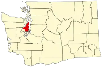 | |
| CDPs |
| |
| Other communities |
| |
| Indian reservation |
| |