Anacortes, Washington
Anacortes, Washington | |
|---|---|
City | |
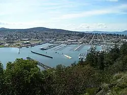 View of the downtown and marina of Anacortes from Cap Sante, c. 2006 | |
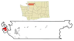 | |
| Coordinates: 48°30′07″N 122°37′25″W / 48.50194°N 122.62361°W | |
| Country | United States |
| State | Washington |
| County | Skagit |
| Government | |
| • Type | Mayor–council |
| • Mayor | Matt Miller[1] |
| Area | |
| • Total | 15.65 sq mi (40.53 km2) |
| • Land | 11.70 sq mi (30.30 km2) |
| • Water | 3.95 sq mi (10.23 km2) |
| Elevation | 246 ft (75 m) |
| Population | |
| • Total | 17,637 |
| • Estimate (2021)[5] | 17,832 |
| • Density | 1,498.16/sq mi (578.45/km2) |
| Time zone | UTC-8 (PST) |
| • Summer (DST) | UTC-7 (PDT) |
| ZIP code | 98221 |
| Area code | 360 |
| FIPS code | 53-01990 |
| GNIS feature ID | 2409702[3] |
| Website | cityofanacortes |
Anacortes is a city in Skagit County, Washington, United States. It was founded on May 19, 1891. As of the 2021 United States census, 17,832 people lived there.
References
- ↑ "Archived copy". Archived from the original on December 12, 2025. Retrieved December 28, 2025.
{{cite web}}: CS1 maint: archived copy as title (link) - ↑ "2019 U.S. Gazetteer Files". United States Census Bureau. Retrieved August 7, 2020.
- 1 2 U.S. Geological Survey Geographic Names Information System: Anacortes, Washington
- ↑ "Explore Census Data". United States Census Bureau. Retrieved June 22, 2022.
- ↑ "City and Town Population Totals: 2020–2021". United States Census Bureau. June 22, 2022. Retrieved June 22, 2022.
Municipalities and communities of Skagit County, Washington, United States | ||
|---|---|---|
| Cities | 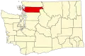 | |
| Towns |
| |
| CDPs |
| |
| Other communities |
| |
| Indian reservation |
| |
| Ghost towns |
| |