List of cities and towns in Rhode Island
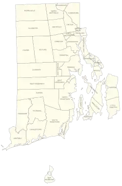
The U.S. state of Rhode Island is divided into 8 cities and 31 towns. Each city or town is a municipality with its own government. Everywhere in Rhode Island is within a city or town.
Cities and towns
† State capital and largest city
| Name | Type[1] | County | Form of government[1] | Population (2020)[2] |
Land area (2020)[3] |
Population density | Year established [1] |
Year incorporated [a][1][4] | |
|---|---|---|---|---|---|---|---|---|---|
| sq mi | km2 | ||||||||
| Barrington | Town | Bristol | Council–manager | 17,153 | 8.22 | 21.3 | 2,086.7/sq mi (805.7/km2) | 1653 | 1770 |
| Bristol | Town | Bristol | Council–manager | 22,493 | 9.82 | 25.4 | 2,290.5/sq mi (884.4/km2) | 1680 | 1746 |
| Burrillville | Town | Providence | Council–manager | 16,158 | 55.03 | 142.5 | 293.6/sq mi (113.4/km2) | 1730 | 1806 |
| Central Falls | City | Providence | Mayor–council | 22,583 | 1.20 | 3.1 | 18,819.2/sq mi (7,266.1/km2) | 1730 | 1895 |
| Charlestown | Town | Washington | Council–manager | 7,997 | 36.45 | 94.4 | 219.4/sq mi (84.7/km2) | 1669 | 1738 |
| Coventry | Town | Kent | Council–manager | 35,688 | 59.05 | 152.9 | 604.4/sq mi (233.3/km2) | 1639 | 1743[b] |
| Cranston | City | Providence | Mayor–council | 82,934 | 28.34 | 73.4 | 2,926.4/sq mi (1,129.9/km2) | 1754 | 1910 |
| Cumberland | Town | Providence | Mayor–council | 36,405 | 26.45 | 68.5 | 1,376.4/sq mi (531.4/km2) | 1746 | 1746 |
| East Greenwich | Town | Kent | Council–manager | 14,312 | 16.39 | 42.4 | 873.2/sq mi (337.2/km2) | 1677 | 1677[c] |
| East Providence | City | Providence | Mayor–council | 47,139 | 13.24 | 34.3 | 3,560.3/sq mi (1,374.7/km2) | 1812 | 1958 |
| Exeter | Town | Washington | Town meeting | 6,460 | 57.47 | 148.8 | 112.4/sq mi (43.4/km2) | 1641 | 1641[d] |
| Foster | Town | Providence | Town meeting | 4,469 | 50.80 | 131.6 | 88.0/sq mi (34.0/km2) | 1636 | 1781 |
| Glocester | Town | Providence | Town meeting | 9,974 | 54.18 | 140.3 | 184.1/sq mi (71.1/km2) | 1639 | 1730–1731 |
| Hopkinton | Town | Washington | Town meeting | 8,398 | 42.95 | 111.2 | 195.5/sq mi (75.5/km2) | 1639 | 1757 |
| Jamestown | Town | Newport | Council–manager | 5,559 | 9.45 | 24.5 | 588.3/sq mi (227.1/km2) | 1639 | 1678 |
| Johnston | Town | Providence | Mayor–council | 29,568 | 23.43 | 60.7 | 1,262.0/sq mi (487.3/km2) | 1636 | 1759 |
| Lincoln | Town | Providence | Council–manager | 22,529 | 18.12 | 46.9 | 1,243.3/sq mi (480.0/km2) | 1650 | 1871 |
| Little Compton | Town | Newport | Town meeting | 3,616 | 20.52 | 53.1 | 176.2/sq mi (68.0/km2) | 1682 | 1746 |
| Middletown | Town | Newport | Council–manager | 17,075 | 12.72 | 32.9 | 1,342.4/sq mi (518.3/km2) | 1639 | 1743 |
| Narragansett | Town | Washington | Council–manager | 14,532 | 13.89 | 36.0 | 1,046.2/sq mi (403.9/km2) | 1888 | 1901 |
| Newport | City | Newport | Council–manager | 25,163 | 7.67 | 19.9 | 3,280.7/sq mi (1,266.7/km2) | 1639 | 1784[e] |
| New Shoreham | Town | Washington | Council–manager | 1,410 | 9.08 | 23.5 | 155.3/sq mi (60.0/km2) | 1664 | 1672 |
| North Kingstown | Town | Washington | Council–manager | 27,732 | 43.14 | 111.7 | 642.8/sq mi (248.2/km2) | 1641 | 1674 |
| North Providence | Town | Providence | Mayor–council | 34,114 | 5.62 | 14.6 | 6,070.1/sq mi (2,343.7/km2) | 1636 | 1765 |
| North Smithfield | Town | Providence | Council–manager | 12,588 | 23.80 | 61.6 | 528.9/sq mi (204.2/km2) | 1730 | 1871 |
| Pawtucket | City | Providence | Mayor–council | 75,604 | 8.68 | 22.5 | 8,710.1/sq mi (3,363.0/km2) | 1671 | 1954 |
| Portsmouth | Town | Newport | Council–manager | 17,871 | 22.98 | 59.5 | 777.7/sq mi (300.3/km2) | 1638 | 1640[f] |
| Providence† | City | Providence | Mayor–council | 190,934 | 18.40 | 47.7 | 10,376.8/sq mi (4,006.5/km2) | 1636 | 1832 |
| Richmond | Town | Washington | Town meeting | 8,020 | 40.29 | 104.4 | 199.1/sq mi (76.9/km2) | 1636 | 1730 |
| Scituate | Town | Providence | Town meeting | 10,384 | 48.16 | 124.7 | 215.6/sq mi (83.2/km2) | 1636 | 1730 |
| Smithfield | Town | Providence | Council–manager | 22,118 | 26.31 | 68.1 | 840.7/sq mi (324.6/km2) | 1636 | 1730 |
| South Kingstown | Town | Washington | Council–manager | 31,931 | 56.45 | 146.2 | 565.7/sq mi (218.4/km2) | 1657 | 1723[g] |
| Tiverton | Town | Newport | Town meeting | 16,359 | 29.05 | 75.2 | 563.1/sq mi (217.4/km2) | 1694 | 1746 |
| Warren | Town | Bristol | Council–manager | 11,147 | 6.12 | 15.9 | 1,821.4/sq mi (703.2/km2) | 1620 | 1747 |
| Warwick | City | Kent | Mayor–council | 82,823 | 35.04 | 90.8 | 2,363.7/sq mi (912.6/km2) | 1642 | 1931 |
| Westerly | Town | Washington | Council–manager | 23,359 | 29.52 | 76.5 | 791.3/sq mi (305.5/km2) | 1661 | 1669 |
| West Greenwich | Town | Kent | Town meeting | 6,528 | 50.26 | 130.2 | 129.9/sq mi (50.1/km2) | 1639 | 1741 |
| West Warwick | Town | Kent | Council–manager | 31,012 | 7.79 | 20.2 | 3,981.0/sq mi (1,537.1/km2) | 1648 | 1913 |
| Woonsocket | City | Providence | Mayor–council | 43,240 | 7.74 | 20.0 | 5,586.6/sq mi (2,157.0/km2) | 1867 | 1888 |
| Total | — | — | — | 1,097,379 | 1,033.82 | 2,677.6 | 1,061.48/sq mi (409.84/km2) | — | — |
Notes
- ↑ Refers to the date of incorporation of the current municipal status.
- ↑ There is a discrepancy in dates from the two provided sources, with the Snow (1865) source listing the incorporation date as 1741.
- ↑ This date is only found in the Snow (1865) source and is absent in the Government of Rhode Island source.
- ↑ There is a discrepancy in dates from the two provided sources, with the Snow (1865) source listing the incorporation date as 1742–1743.
- ↑ This date is only found in the Government of Rhode Island source and is absent in the Snow (1865) source.
- ↑ This date is only found in the Snow (1865) source and is absent in the Government of Rhode Island source.
- ↑ There is a discrepancy in dates from the two provided sources, with the Snow (1865) source listing the incorporation date as 1722.
References
- 1 2 3 4 "Rhode Island Cities & Towns". Rhode Island Government. Rhode Island Interactive. Retrieved March 5, 2017.
- ↑ "Explore Census Data". U.S. Census Bureau. Retrieved August 25, 2021.
- ↑ "GCT-PH1 – Population, Housing Units, Area, and Density: 2010 – State — Place and (in selected states) County Subdivision". 2010 United States Census. United States Census Bureau. Archived from the original on September 16, 2020. Retrieved June 17, 2016.
- ↑ Snow, Edwin M. (1865). Report Upon the Census of Rhode Island, 1865: With the Statistics of the Population, Agriculture, Fisheries and Manufactures of the State. Rhode Island Census Board. University of Michigan. p. xxvii.
Providence (capital) | ||
| Topics |
| |
| Society |
| |
| Regions |
| |
| Cities | ||
| Towns |
| |