Tiverton, Rhode Island
Tiverton, Rhode Island | |
|---|---|
 Nanaquaket Pond, Tiverton, RI | |
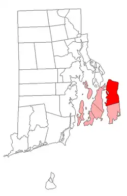 Location of Tiverton in Newport County, Rhode Island | |
| Coordinates: 41°37′35″N 71°12′40″W / 41.62639°N 71.21111°W | |
| Country |  United States |
| State |  Rhode Island |
| County | Newport |
| Settled | 1659 |
| Incorporated (Massachusetts) | June 14, 1694 |
| Annexed by Rhode Island | January 27, 1747 |
| Area | |
| • Total | 36.3 sq mi (94.1 km2) |
| • Land | 29.4 sq mi (76.0 km2) |
| • Water | 7.0 sq mi (18.0 km2) |
| Elevation | 167 ft (51 m) |
| Population (2020) | |
| • Total | 16,359 |
| • Density | 558/sq mi (215.3/km2) |
| Time zone | UTC−5 (Eastern (EST)) |
| • Summer (DST) | UTC−4 (EDT) |
| ZIP Code | 02878 |
| Area code | 401 |
| FIPS code | 44-70880[2] |
| GNIS feature ID | 1220066[1] |
| Website | www |
Tiverton is a town in Newport County, Rhode Island, United States. As at the 2020 census, its population was 16,359.
Municipalities and communities of Newport County, Rhode Island, United States | ||
|---|---|---|
| City |  | |
| Towns | ||
| CDPs |
| |
| Other villages |
| |
- 1 2 U.S. Geological Survey Geographic Names Information System: Tiverton, Rhode Island
- ↑ "U.S. Census website". United States Census Bureau. Retrieved January 31, 2008.