Wrightsville Beach, North Carolina
Wrightsville Beach, North Carolina | |
|---|---|
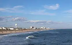 Wrightsville Beach shoreline seen from Crystal Pier | |
 Location in New Hanover County and the state of North Carolina. | |
| Coordinates: 34°12′41″N 77°47′47″W / 34.21139°N 77.79639°W | |
| Country | United States |
| State | North Carolina |
| County | New Hanover |
| Township | Harnett Township |
| Named for | Joshua G. Wright |
| Government | |
| • Mayor | Darryl Mills[1] |
| Area | |
| • Total | 2.27 sq mi (5.89 km2) |
| • Land | 1.40 sq mi (3.61 km2) |
| • Water | 0.88 sq mi (2.28 km2) |
| Elevation | 0 ft (0 m) |
| Population (2020) | |
| • Total | 2,473 |
| • Density | 1,772.76/sq mi (684.67/km2) |
| Time zone | UTC-5 (Eastern (EST)) |
| • Summer (DST) | UTC-4 (EDT) |
| ZIP code | 28480 |
| Area codes | 910, 472 |
| FIPS code | 37-75820[4] |
| GNIS feature ID | 2406920[3] |
| Website | www |
Wrightsville Beach is a town in New Hanover County, North Carolina, United States. Wrightsville Beach is just east of Wilmington and is part of the Wilmington metropolitan area. The population was 2,473 at the 2020 census.
References
- ↑ "Elected Officials". New Hanover County Board of Elections. Archived from the original on December 10, 2022. Retrieved April 23, 2022.
- ↑ "ArcGIS REST Services Directory". United States Census Bureau. Retrieved September 20, 2022.
- 1 2 U.S. Geological Survey Geographic Names Information System: Wrightsville Beach, North Carolina
- ↑ "U.S. Census website". United States Census Bureau. Retrieved January 31, 2008.
Municipalities and communities of New Hanover County, North Carolina, United States | ||
|---|---|---|
| City | 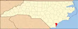 | |
| Towns | ||
| CDPs |
| |
| Unincorporated communities |
| |