Warrington, New Zealand
Warrington
Ōkāhau | |
|---|---|
Town | |
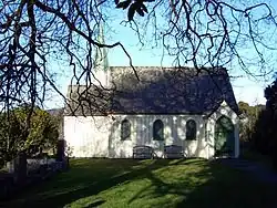 St Barnabas Church | |
| Coordinates: 45°42′36″S 170°35′39″E / 45.7101°S 170.5941°E | |
| Country | New Zealand |
| Island | South Island |
| Region | Otago |
| District | Dunedin |
| Community board | Waikouaiti Coast Community Board[1] |
| Electorates |
|
| Government | |
| • Territorial authority | Dunedin City Council |
| • Regional council | Otago Regional Council |
| • Mayor of Dunedin | Sophie Barker[2] |
| • Dunedin MP | Rachel Brooking |
| • Te Tai Tonga MP | Tākuta Ferris |
| Area | |
| • Total | 7.39 km2 (2.85 sq mi) |
| Population (June 2023)[4] | |
| • Total | 550 |
| • Density | 74/km2 (190/sq mi) |
| Time zone | UTC+12 (NZST) |
| • Summer (DST) | UTC+13 (NZDT) |
| Area code | 03 |
| Local iwi | Ngāi Tahu |
Warrington is a small settlement in Otago. It is 22 kilometers north of Dunedin and 3 kilometers off State Highway 1. It has a primary school in the settlement.
References
- ↑ "2016 Waikouaiti Coast Community Board Boundary" (PDF). dunedin.govt.nz. Dunedin City Council. Retrieved 2 June 2022.
- ↑ "2025 Triennial Elections Declaration of Result" (PDF). Electionz. Retrieved 17 October 2025.
- ↑ "ArcGIS Web Application". statsnz.maps.arcgis.com. Retrieved 6 January 2022.
- ↑ "Subnational population estimates (RC, SA2), by age and sex, at 30 June 1996-2023 (2023 boundaries)". Statistics New Zealand. Retrieved 25 October 2023. (regional councils); "Subnational population estimates (TA, SA2), by age and sex, at 30 June 1996-2023 (2023 boundaries)". Statistics New Zealand. Retrieved 25 October 2023. (territorial authorities); "Subnational population estimates (urban rural), by age and sex, at 30 June 1996-2023 (2023 boundaries)". Statistics New Zealand. Retrieved 25 October 2023. (urban areas)