Transverse Ranges
| Transverse Ranges | |
|---|---|
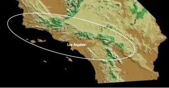 The ellipse outlines the region of the California Transverse Ranges | |
| Highest point | |
| Peak | San Gorgonio Mountain |
| Elevation | 11,503 ft (3,506 m) |
| Coordinates | 34°05′57″N 116°49′29″W / 34.099162°N 116.824853°W |
| Dimensions | |
| Length | 300 mi (480 km) |
| Geography | |
| Country | United States |
| Parent range | Pacific Coast Ranges |
The Transverse Ranges are a group of mountain ranges in Southern California. They are part of the Pacific Coast Ranges, on the western side of North America. They go through Santa Barbara, Ventura, Los Angeles, San Bernardino, Riverside, and Kern counties.
The Transverse Ranges go from west to east, unlike other nearby mountain ranges, which go from northwest to northeast. For this reason, they are called "transverse", which means lying across something else. They are south of the California Coast Ranges and north of the Peninsular Ranges.[1][2][3][4]
Most of the ranges are in the California chaparral and woodlands ecoregion. At lower elevations, the plant life is chaparral. At higher elevations, there are large conifer forests. Most of the ranges in the system are fault blocks. They were lifted up by tectonic movements late in the Cenozoic Era.[1]
Geography
The ranges are around 300 miles (500 kilometres) in length. The western part stretches from the Pacific coast to the San Gabriel Fault, the central part stretches to the San Andreas Fault, and the eastern part stretches to the Mojave Desert. The central and eastern ranges are higher.[1]
The Transverse Ranges are made of roughly parallel ridges. The average height is 3,000–8,000 feet (900–2,400 m). Many young, steep streams cut through the mountains. As a result, there are many low canyons next to high mountains. There are no large flat areas in the Transverse Ranges.
The mountains are hard to cross because they are so steep. Only a few mountain passes are low enough and wide enough for many people to cross them. For example, most traffic between Los Angeles and the Central Valley goes through Tejon Pass. When passes are closed because of snow or road work, this causes serious traffic problems in Southern California.
Peaks
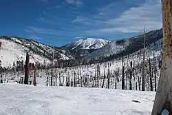
Major peaks of the Transverse Ranges with at least 500 feet (150 m) of prominence, listed by height:
- Mount San Gorgonio, 11,503 feet (3,506 m), San Bernardino Mountains.
- Anderson Peak, 10,840 feet (3,300 m), San Bernardino Mountains.
- Mount San Antonio (Old Baldy), 10,068 feet (3,069 m), San Gabriel Mountains.
- Sugarloaf Mountain, 9,952 feet (3,033 m), San Bernardino Mountains.
- Mount Baden-Powell, 9,407 feet (2,867 m), San Gabriel Mountains.
- Galena Peak, 9,324 feet (2,842 m), San Bernardino Mountains.
- Throop Peak, 9,142 feet (2,786 m), San Gabriel Mountains.
- Telegraph Peak, 8,985 feet (2,739 m), San Gabriel Mountains.
- Cucamonga Peak, 8,862 feet (2,701 m), San Gabriel Mountains.
- Mount Pinos, 8,847 feet (2,697 m).
- Ontario Peak, 8,693 feet (2,650 m), San Gabriel Mountains.
- Delamar Mountain, 8,402 feet (2,561 m), San Bernardino Mountains.
- Cerro Noroeste, 8,280 feet (2,520 m).
- Mount Islip, 8,254 feet (2,516 m), San Gabriel Mountains.
- Gold Mountain, 8,239 feet (2,511 m), San Bernardino Mountains.
- Bertha Peak, 8,205 feet (2,501 m), San Bernardino Mountains.
- Frazier Mountain, 8,017 feet (2,444 m).
- Iron Mountain #1, 8,010 feet (2,440 m), San Gabriel Mountains.
- Reyes Peak, 7,510 feet (2,290 m), Pine Mountain Ridge.
- Haddock Mountain, 7,431 feet (2,265 m), Pine Mountain Ridge.
Ranges
Western part
This part starts at Point Conception in Santa Barbara County, and include the Santa Ynez Mountains that run parallel to the coast behind Santa Barbara and the San Rafael Mountains on the other side of the Santa Ynez Valley. The western Transverse Ranges also include the Topatopa Mountains and the Santa Susana Mountains of Ventura County and Los Angeles County, the Simi Hills, the Santa Monica Mountains that run along the Pacific coast behind Malibu, and whose eastern part is known as the Hollywood Hills, and the Chalk Hills. The northern Channel Islands of California are also part of the Transverse Ranges; San Miguel, Santa Rosa, Santa Cruz and Anacapa Islands are a westward extension of the Santa Monica Mountains.
Central part
The central ranges include the steep San Gabriel Mountains northeast of Los Angeles, the Sierra Pelona Mountains just south of the San Andreas fault, the Tehachapi Mountains southeast of Bakersfield, the Verdugo Mountains, the Liebre-Sawmill Mountains, the San Rafael Hills, Puente Hills, San Jose Hills, and Chino Hills.
Eastern part
The San Bernardino Mountains, Little San Bernardino Mountains, and the Pinto, Eagle, and Orocopia Mountains are within the eastern part. The Mojave Desert and California's low desert, including the Coachella Valley, are at the eastern end of the ranges.
Ranges north of the western part that nearly go west to east, but are part of the California Coast Ranges, include the San Rafael Mountains and the Sierra Madre Mountains. Likewise, the Tehachapi Mountains north of the Mojave Desert, which nearly go west to east, are the southern end of the Sierra Nevada.
Component ranges
Mountain ranges with peaks higher than 4,500 feet (1,400 m), listed west to east, include:
- Santa Ynez Mountains
- San Rafael Mountains
- Pine Mountain Ridge
- San Emigdio Mountains
- Topatopa Mountains
- Sierra Pelona Ridge
- San Gabriel Mountains
- San Bernardino Mountains
- Little San Bernardino Mountains
Examples of smaller mountain and hill ranges include:
- Santa Monica Mountains
- Santa Susana Mountains
- Simi Hills
- Chalk Hills
- Indio Hills
- San Rafael Hills
- Puente Hills
- San Jose Hills
- Shandin Hills
Climate
The climate in most of the range is Csb (Warm-summer Mediterranean) under the Köppen climate classification. The upper parts of San Gorgonio Mountain have an alpine tundra climate (ET). The lower northern slopes of the range have a desert (BW) or steppe (BS) climate. Most of the nearby lowlands to the south and west have a Hot-summer Mediterranean climate (Csa).[5]
Snow falls above 6,000 feet (1,800 m) most winters, and above 3,000 feet (900 m) every few years. It is rare for elevations above 8,000 feet (2,000 m) to go multiple winters without snow, even during severe droughts. Because of relatively low humidity, the regional snow line lies at about 14,000–16,000 feet (4,000–5,000 m), above the highest elevation of the range. This means that snow does not stay on the ground all year, except in the form of snow patches.
The tree line lies at about 11,000 feet (3,000 m). San Gorgonio Mountain is the only peak that reaches above the tree line.
Geology
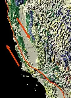
The Transverse Ranges were made by tectonic forces and faults. These come from the northward sliding of the Pacific plate in comparison to the North American plate, along the San Andreas Fault. During the Pliocene (around 4 million years ago), the fault had a sharp leftward bend where the Transverse Ranges are today. The crust within the Pacific Plate south of the ranges can not easily make the left turn westward as the entire plate moves northwestward. So pieces of the crust are forced to compress and lift.[6]
Before the fault shifted to make the left bend, northwest–southeast trending rock belts in all of the Transverse Ranges started to rotate clockwise, becoming perpendicular to the Pacific Plate – North American Plate boundary.[7][8][9] This tectonic rotation began in Early Miocene Time and continues today.[10] The total rotation is about 90° in the Western Transverse Ranges and less (about 40°) in the eastern ranges.[11] Catalina Island shows the most rotation: almost 120°.[8]
This rotation event could be explained by capture of the subducting Monterey plate by the Pacific plate. Because the Monterey plate was then beneath southern California, the capture resulted in pulling of the overlying crust out and northward from the rest of California.[12]
References
- 1 2 3 Dibblee Jr, T.W., 1982. Regional geology of the Transverse Ranges Province of southern California. Geology and mineral wealth of the California Transverse Ranges, 10, pp.7-26.
- ↑ Norris, R. M.; Webb, R. W. (1990). Geology of California. Wiley.
- ↑ Ingram, Scott (2002). California: The Golden State. Gareth Stevens. pp. 21. ISBN 978-0-8368-5282-0.
- ↑ "California's Coastal Mountains". California Coastal Commission. Archived from the original on 2007-12-22. Retrieved 2007-12-25.
- ↑ "Redlands Biology". Archived from the original on 2017-05-25. Retrieved 2014-10-21.
- ↑ Larson, Roger L.; Menard, H. W.; Smith, S. M. (1968-08-23). "Gulf of California: A Result of Ocean-Floor Spreading and Transform Faulting". Science. 161 (3843): 781–784. Bibcode:1968Sci...161..781L. doi:10.1126/science.161.3843.781. ISSN 0036-8075. PMID 17802622. S2CID 31863250.
- ↑ LUYENDYK, BRUCE P.; KAMERLING, MARC J.; TERRES, RICHARD (1980-04-01). "Geometric model for Neogene crustal rotations in southern California". GSA Bulletin. 91 (4): 211. Bibcode:1980GSAB...91..211L. doi:10.1130/0016-7606(1980)91<211:gmfncr>2.0.co;2. ISSN 0016-7606.
- 1 2 Luyendyk, Bruce P.; Kamerling, Marc J.; Terres, Richard R.; Hornafius, J. Scott (1985). "Simple shear of southern California during Neogene time suggested by paleomagnetic declinations". Journal of Geophysical Research. 90 (B14) 12454. Bibcode:1985JGR....9012454L. doi:10.1029/jb090ib14p12454. ISSN 0148-0227.
- ↑ LUYENDYK, BRUCE P. (1991-11-01). "A model for Neogene crustal rotations, transtension, and transpression in southern California". GSA Bulletin. 103 (11): 1528. Bibcode:1991GSAB..103.1528L. doi:10.1130/0016-7606(1991)103<1528:amfncr>2.3.co;2. ISSN 0016-7606.
- ↑ HORNAFIUS, J. SCOTT; LUYENDYK, BRUCE P.; TERRES, R. R.; KAMERLING, M. J. (1986-12-01). "Timing and extent of Neogene tectonic rotation in the western Transverse Ranges, California". GSA Bulletin. 97 (12): 1476. Bibcode:1986GSAB...97.1476S. doi:10.1130/0016-7606(1986)97<1476:taeont>2.0.co;2. ISSN 0016-7606.
- ↑ CARTER, JAMES N.; LUYENDYK, BRUCE P.; TERRES, RICHARD R. (1987-02-01). "Neogene clockwise tectonic rotation of the eastern Transverse Ranges, California, suggested by paleomagnetic vectors". GSA Bulletin. 98 (2): 199. Bibcode:1987GSAB...98..199C. doi:10.1130/0016-7606(1987)98<199:nctrot>2.0.co;2. ISSN 0016-7606.
- ↑ Nicholson, Craig; Sorlien, Christopher C.; Atwater, Tanya; Crowell, John C.; Luyendyk, Bruce P. (1994-06-01). "Microplate capture, rotation of the western Transverse Ranges, and initiation of the San Andreas transform as a low-angle fault system". Geology. 22 (6): 491. Bibcode:1994Geo....22..491N. doi:10.1130/0091-7613(1994)022<0491:mcrotw>2.3.co;2. ISSN 0091-7613.
Other websites
