Soap Lake, Washington
Soap Lake | |
|---|---|
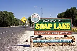 Welcome sign in Soap Lake | |
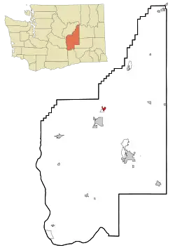 Location of Soap Lake, Washington | |
| Coordinates: 47°23′31″N 119°29′45″W / 47.39194°N 119.49583°W | |
| Country | United States |
| State | Washington |
| County | Grant |
| Area | |
| • Total | 1.61 sq mi (4.16 km2) |
| • Land | 1.54 sq mi (3.98 km2) |
| • Water | 0.07 sq mi (0.18 km2) |
| Elevation | 1,079 ft (329 m) |
| Population | |
| • Total | 1,691 |
| • Density | 1,042.94/sq mi (402.69/km2) |
| Time zone | UTC-8 (Pacific (PST)) |
| • Summer (DST) | UTC-7 (PDT) |
| ZIP code | 98851 |
| Area code | 509 |
| FIPS code | 53-65345 |
| GNIS feature ID | 2411918[2] |
| Website | soaplakewa.gov |
Soap Lake is a city in Grant County, Washington, United States. It was founded on June 9, 1919. As of the 2020 United States census, 1,691 people lived there.
References
- ↑ "2019 U.S. Gazetteer Files". United States Census Bureau. Retrieved August 7, 2020.
- 1 2 U.S. Geological Survey Geographic Names Information System: Soap Lake, Washington
- ↑ "2020 Census Redistricting Data (Public Law 94-171) Summary File". American FactFinder. United States Census Bureau. Retrieved March 18, 2022.
Municipalities and communities of Grant County, Washington, United States | ||
|---|---|---|
| Cities |  | |
| Towns |
| |
| CDPs |
| |
| Other communities |
| |
| Ghost towns |
| |
| Footnotes | ‡This populated place also has portions in an adjacent county or counties | |