Rosedale, Maryland
Rosedale, Maryland | |
|---|---|
 Pulaski Highway near Chesaco Avenue in Rosedale, Maryland | |
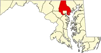
 Location of Rosedale, Maryland | |
| Coordinates: 39°19′42″N 76°30′40″W / 39.32833°N 76.51111°W | |
| Country |  United States |
| State |  Maryland |
| County |  Baltimore |
| Area | |
| • Total | 7.10 sq mi (18.40 km2) |
| • Land | 6.86 sq mi (17.78 km2) |
| • Water | 0.24 sq mi (0.62 km2) |
| Elevation | 20 ft (6 m) |
| Population (2020) | |
| • Total | 19,961 |
| • Density | 2,908.49/sq mi (1,122.92/km2) |
| Time zone | UTC−5 (Eastern (EST)) |
| • Summer (DST) | UTC−4 (EDT) |
| ZIP code | 21237 |
| Area code | 410 |
| FIPS code | 24-68400 |
| GNIS feature ID | 0591183 |
Rosedale is an unincorporated community and census-designated place in Baltimore County, Maryland, United States. The population was 19,961 at the 2020 United States census.[2]
References
- ↑ "2020 U.S. Gazetteer Files". United States Census Bureau. Retrieved April 26, 2022.
- ↑ "Rosedale CDP, Maryland - Census Bureau Profile". U.S. Census Bureau. Retrieved November 24, 2025.
Municipalities and communities of Baltimore County, Maryland, United States | ||
|---|---|---|
| CDPs |
|  |
| Other communities |
| |