Palo Cedro, California
Palo Cedro | |
|---|---|
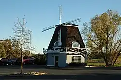 Windmill, Downtown Palo Cedro | |
 Location in Shasta County and the state of California | |
| Coordinates: 40°33′4″N 122°14′3″W / 40.55111°N 122.23417°W | |
| Country |  United States |
| State |  California |
| County | Shasta |
| Area | |
| • Total | 8.288 sq mi (21.465 km2) |
| • Land | 8.179 sq mi (21.185 km2) |
| • Water | 0.108 sq mi (0.281 km2) 1.31% |
| Elevation | 465 ft (143 m) |
| Population (2020)[2] | |
| • Total | 2,931 |
| • Density | 350/sq mi (140/km2) |
| Time zone | UTC−8 (Pacific (PST)) |
| • Summer (DST) | UTC−7 (PDT) |
| ZIP code | 96073 |
| Area code | 530 |
| FIPS code | 06-55296 |
| GNIS feature ID | 0230275 |
Palo Cedro (Spanish for "Cedar Wood") is a census-designated place (CDP) in Shasta County, California, United States. It is 8 miles (13 km) east of Redding, California. Its population is 2,931 as of the 2020 census.[2]
References
- ↑ "2020 U.S. Gazetteer Files". United States Census Bureau. Retrieved June 29, 2025.
- 1 2 "Palo Cedro CDP, California". United States Census Bureau. Retrieved August 30, 2023.
Municipalities and communities of Shasta County, California, United States | ||
|---|---|---|
| Cities | 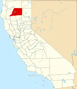 | |
| CDPs |
| |
| Unincorporated communities |
| |
| Indian reservations |
| |
| Ghost towns |
| |
| Footnotes | ‡This populated place also has portions in an adjacent county or counties | |