Oxford, New Zealand
Oxford
| |
|---|---|
Minor urban area | |
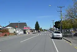 The main street (Inland Scenic Route) of Oxford | |
| Coordinates: 43°18′46″S 172°11′26″E / 43.31278°S 172.19056°E | |
| Country | New Zealand |
| Region | Canterbury |
| Territorial authority | Waimakariri District |
| Ward | Oxford-Ohoka Ward |
| Community | Oxford-Ohoka Community |
| Electorates |
|
| Government | |
| • Territorial Authority | Waimakariri District Council |
| • Regional council | Environment Canterbury |
| • Mayor of Waimakariri | Dan Gordon[2] |
| • Waimakariri MP | Matt Doocey |
| • Te Tai Tonga MP | Tākuta Ferris |
| Area | |
| • Total | 11.82 km2 (4.56 sq mi) |
| Elevation | 235 m (771 ft) |
| Population (June 2023)[4] | |
| • Total | 2,380 |
| • Density | 200/km2 (520/sq mi) |
| Time zone | UTC+12 (NZST) |
| • Summer (DST) | UTC+13 (NZDT) |
| Postcode(s) | 7430 |
| Area code | 03 |
| Website | www |
Oxford is a town in the Waimakariri District, New Zealand. It is located 32 kilometers west of Rangiora and is west of towns Darfield and Sheffield. It has an area school and several community organisations.
References
- ↑ "Electorate Boundaries". Archived from the original on 8 February 2013. Retrieved 7 June 2015.
- ↑ "2025 Triennial Elections Declaration of Result" (PDF). Electionz. Retrieved 22 October 2025.
- ↑ "ArcGIS Web Application". statsnz.maps.arcgis.com. Archived from the original on 24 March 2023. Retrieved 29 April 2024.
- ↑ "Subnational population estimates (RC, SA2), by age and sex, at 30 June 1996-2023 (2023 boundaries)". Statistics New Zealand. Retrieved 25 October 2023. (regional councils); "Subnational population estimates (TA, SA2), by age and sex, at 30 June 1996-2023 (2023 boundaries)". Statistics New Zealand. Retrieved 25 October 2023. (territorial authorities); "Subnational population estimates (urban rural), by age and sex, at 30 June 1996-2023 (2023 boundaries)". Statistics New Zealand. Retrieved 25 October 2023. (urban areas)