Norsewood
Norsewood | |
|---|---|
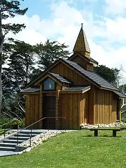 Stave church replica on Coronation Street. | |
| Coordinates: 40°04′S 176°13′E / 40.067°S 176.217°E | |
| Country | New Zealand |
| Region | Manawatū-Whanganui |
| Territorial authority | Tararua District |
| Ward |
|
| Community | Dannevirke Community |
| Electorates | |
| Government | |
| • Type | Territorial Authority |
| • Body | Tararua District Council |
| • Tararua Mayor | Scott Gilmore[1] |
| • Wairarapa MP | Mike Butterick[2] |
| • Ikaroa-Rāwhiti MP | Cushla Tangaere-Manuel[3] |
| • Regional council | Horizons Regional Council |
| Area | |
| • Total | 0.38 km2 (0.15 sq mi) |
| Population (June 2023)[5] | |
| • Total | 150 |
| • Density | 390/km2 (1,000/sq mi) |
| Time zone | UTC+12 (NZST) |
| • Summer (DST) | UTC+13 (NZDT) |
| Postcode | 4974 |
Norsewood is a small settlement in the Tararua District, New Zealand. It is located 20 kilometers northeast of Dannevirke on State Highway 2. It was founded in 1872 by Norwegian settlers.
References
- ↑ "2025 Triennial Elections Declaration of Result" (PDF). Electionz. Retrieved 21 October 2025.
- ↑ "Wairarapa - Official Result". Electoral Commission. Retrieved 19 September 2025.
- ↑ "Ikaroa-Rāwhiti – Official Result". New Zealand Electoral Commission. Retrieved 28 July 2025.
- ↑ "ArcGIS Web Application". statsnz.maps.arcgis.com. Retrieved 12 May 2023.
- ↑ "Subnational population estimates (RC, SA2), by age and sex, at 30 June 1996-2023 (2023 boundaries)". Statistics New Zealand. Retrieved 25 October 2023. (regional councils); "Subnational population estimates (TA, SA2), by age and sex, at 30 June 1996-2023 (2023 boundaries)". Statistics New Zealand. Retrieved 25 October 2023. (territorial authorities); "Subnational population estimates (urban rural), by age and sex, at 30 June 1996-2023 (2023 boundaries)". Statistics New Zealand. Retrieved 25 October 2023. (urban areas)