Matamata
Matamata | |
|---|---|
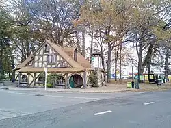 Matamata information centre | |
| Coordinates: 37°49′S 175°46′E / 37.817°S 175.767°E | |
| Country | New Zealand |
| Region | Waikato |
| Territorial authority | Matamata-Piako District |
| Ward | Matamata Ward |
| Electorate | Waikato |
| Government | |
| • Territorial Authority | Matamata-Piako District Council |
| • Regional council | Waikato Regional Council |
| • Mayor | Ash Tanner[1] |
| Area | |
| • Total | 6.15 km2 (2.37 sq mi) |
| Elevation | 63 m (207 ft) |
| Population (June 2023)[3] | |
| • Total | 9,130 |
| • Density | 1,500/km2 (3,800/sq mi) |
| Time zone | UTC+12 (NZST) |
| • Summer (DST) | UTC+13 (NZDT) |
| Postcode | 3400 |
| Area code | 07 |
Matamata (Māori: [ˈmataˌmata]) is a town in the Waikato, New Zealand and located on State Highway 27. It is part of the Matamata-Piako District and is near the Kaimai Ranges. It is the home of Hobbit Movie Set in the Peter Jackson movie set of Lord of the Rings.
References
- ↑ "2025 Triennial Elections Declaration of Result" (PDF). Electionz. Retrieved 18 October 2025.
- ↑ "ArcGIS Web Application". statsnz.maps.arcgis.com. Retrieved 13 October 2022.
- ↑ "Subnational population estimates (RC, SA2), by age and sex, at 30 June 1996-2023 (2023 boundaries)". Statistics New Zealand. Retrieved 25 October 2023. (regional councils); "Subnational population estimates (TA, SA2), by age and sex, at 30 June 1996-2023 (2023 boundaries)". Statistics New Zealand. Retrieved 25 October 2023. (territorial authorities); "Subnational population estimates (urban rural), by age and sex, at 30 June 1996-2023 (2023 boundaries)". Statistics New Zealand. Retrieved 25 October 2023. (urban areas)