Magnolia, Texas
Magnolia, Texas | |
|---|---|
City | |
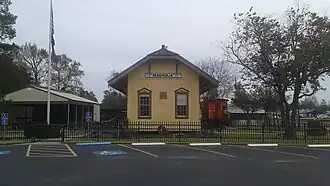 Historic train depot in downtown Magnolia | |
| Nickname: Home of Red | |
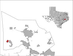 Location of Magnolia, Texas | |
| Coordinates: 30°12′34″N 95°45′03″W / 30.20944°N 95.75083°W | |
| Country | United States |
| State | Texas |
| County | Montgomery |
| Founded | 1840's |
| Incorporated | October 15, 1968 |
| Government | |
| • Type | General Law Type A |
| • Mayor | Matthew "Doc" Dantzer |
| • Mayor Pro Tem | Richard Carby[2] |
| • Councilmembers | Daniel Miller Buck Perino Richard Carby Brandon Jacobs Jack L Huitt, Jr. |
| Area | |
| • Total | 4.865 sq mi (12.600 km2) |
| • Land | 4.845 sq mi (12.547 km2) |
| • Water | 0.020 sq mi (0.053 km2) |
| Elevation | 272 ft (83 m) |
| Population | |
| • Total | 2,359 |
| • Estimate (2023)[6] | 5,320 |
| • Density | 1,098/sq mi (424.0/km2) |
| Time zone | UTC–6 (Central (CST)) |
| • Summer (DST) | UTC–5 (CDT) |
| ZIP Codes | 77353, 77354, 77355 |
| Area codes | 713, 281, 832, 346, 621 |
| FIPS code | 48-46056 |
| GNIS feature ID | 1340838[4] |
| Sales tax | 8.25%[7] |
| Website | cityofmagnolia.com |
Magnolia is a city in Montgomery County, Texas, United States. It was founded in 1845. As of the 2023 United States census, 5,320 people lived there.
References
- ↑ "Mayor & City Council". City of Magnolia, Texas. September 20, 2024.
- ↑ "Richard Carby". City of Magnolia, Texas. September 20, 2024.
- ↑ "2024 U.S. Gazetteer Files". United States Census Bureau. Retrieved September 20, 2024.
- 1 2 U.S. Geological Survey Geographic Names Information System: Magnolia, Texas
- ↑ "Explore Census Data". United States Census Bureau. Retrieved September 20, 2024.
- ↑ "City and Town Population Totals: 2020-2023". United States Census Bureau. September 20, 2024. Retrieved September 20, 2024.
- ↑ "Magnolia (TX) sales tax rate". Retrieved September 20, 2024.
Municipalities and communities of Montgomery County, Texas, United States | ||
|---|---|---|
| Cities |  | |
| Towns | ||
| CDPs |
| |
| Other communities |
| |
| Ghost town |
| |
| Footnotes | ‡This populated place also has portions in an adjacent county or counties | |