Lora Tehsil
Abbottabad Tehsil
تحصیل لورا | |
|---|---|
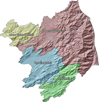 | |
| Country |  Pakistan |
| Province |  Khyber Pakhtunkhwa |
| District | Abbottabad |
| Headquarters | Lora |
| Area | |
| • Total | 187 km2 (72 sq mi) |
| Population (2023)[1] | |
| • Total | 98,717 |
| Time zone | UTC+5 (PST) |
Lora Tehsil (Urdu: تحصیل لورا) is an administrative subdivision (tehsil) of Abbottabad District in the Khyber Pakhtunkhwa province of Pakistan. It is located in the southern part of the district and borders Punjab province.[2] It covers an area of 187km². [3]
History
During the British rule, the district of Abbottabad was created as a Tehsil of Hazara District.[4] After Pakistan′s independence from Britain on 14 August 1947, it was still a tehsil of Hazara until 1981.
In 1981 Abbottabad Tehsil became a district, this district was divided into two tehsils - Abbottabad and Havelian. Lora Tehsil used to be part of Havelian Tehsil but then the government of Pakistan divided Havelian Tehsil and made Lora Tehsil as a new tehsil.
Administration
Lora Tehsil has 6 union council:[5]
- Goreeni
- Lora
- Nagri Totial
- Phallah
- Seer Gharbi
- Seer Sharqi
People
According to the 2023 census the total population of Lora Tehsil was 98,717 of which 48,662 were male and 50,054 were female.[6] The census also recorded religions as follows: 98,326 Muslim, 268 Christians, 10 Hindus, 2 Ahmadi Muslims, 1 Sikh, 1 Parsi and 60 listed as others.[7]
| Religion | Followers | Percentage |
|---|---|---|
| Muslim | 98,326 | 99.65% |
| Christian | 268 | 0.27% |
| Hindu | 10 | 0.01% |
| Ahmadis | 2 | <0.01% |
| Sikh | 1 | <0.01% |
| Parsi | 1 | <0.01% |
| Others | 60 | 0.06% |
The mother tongue of residents were recorded as follows: 4,982 Urdu, 228 Punjabi, 5 Sindhi, 739 Pushto, 6 Balochi, 33 Kashmiri, 58 Saraiki, 83,676 Hindko, 36 Brahvi, 129 Shina, 15 Kalasha, 16 Kohistani and 17 listed as others.[8] The overall literacy rate was 73.73% for the population aged 10 and above with male literacy being 84.09% and female 61.75%.[9]
| Language | Number of speakers | Percentage |
|---|---|---|
| Hindko | 83,676 | 93.01% |
| Urdu | 4,982 | 5.54% |
| Punjabi | 228 | 0.25% |
| Pushto | 739 | 0.82% |
| Shina | 129 | 0.14% |
| Saraiki | 58 | 0.06% |
| Brahvi | 36 | 0.04% |
| Kashmiri | 33 | 0.04% |
| Others | 17 | 0.02% |
| Sindhi | 5 | 0.01% |
| Balochi | 6 | 0.01% |
| Kalasha | 15 | 0.02% |
| Kohistani | 16 | 0.02% |
References
- ↑ TABLE 3 : NUMBER OF RURAL LOCALITIES BY POPULATION SIZE AND THEIR POPULATION BY SEX, CENSUS-2023
- ↑ Abbottabad District map
- ↑ TABLE 1 : AREA, POPULATION BY SEX, SEX RATIO, POPULATION DENSITY, URBAN POPULATION, HOUSEHOLD SIZE AND ANNUAL GROWTH RATE, CENSUS-2023, KHYBER PAKHTUNKHWA
- ↑ "Abbottābād Tahsīl - Imperial Gazetteer of India, v. 5, p. 1". Archived from the original on 2011-06-07. Retrieved 2025-07-20.
- ↑ Weekly Dengue Fever Bulletin - Directorate General Health Services
- ↑ TABLE 3 : NUMBER OF RURAL LOCALITIES BY POPULATION SIZE AND THEIR POPULATION BY SEX, CENSUS-2023
- ↑ TABLE 9 : POPULATION BY SEX, RELIGION AND RURAL/URBAN, CENSUS - 2023
- ↑ TABLE 11 : POPULATION BY MOTHER TONGUE, SEX AND RURAL/URBAN, CENSUS-2023
- ↑ TABLE 12 : LITERACY RATE, ENROLMENT AND OUT OF SCHOOL POPULATION BY SEX AND RURAL/URBAN, CENSUS-2023


Administrative Divisions of Abbottabad District | ||
|---|---|---|
| Capital | | |
| Tehsils | ||
| Union Councils | Abbottabad Central · Bagh · Bagnotar · Bakot · Baldheri · Bandi Atti Khan · Banda Pir Khan · Beerangali · Berote Kalan · Boi · Chamhad · Dalola · Dewal Manal · Dhamtour · Ghari Phulgran · Goreeni · Haveliani Urban · Jarral · Jhangi · Jhangra · Kakul · Kehal Urban · Kukmang · Kuthiala · Kuthwal · Langra · Langrial · Lora · Malikpura Urban · Mirpur · Mojohan · Nagri Bala · Nagri Totial · Nambal · Namli Maira · Nara · Nathia Gali · Nawansher Urban · Palak · Pattan Kalan · Pawa · Phalkot · Phallah · Pind Kargu Khan · Salhad · Sarbhana · Seer Gharbi · Seer Sharqi Bhattian · Sheikh-ul-Bandi · Sherwan · Tajwal | |