Lachin District
Lachin District | |
|---|---|
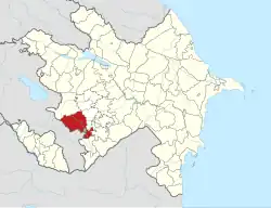 Map of Azerbaijan showing Lachin District | |
| Country |  Azerbaijan |
| Region | Eastern Zangezur |
| Established | 8 August 1930 |
| Capital | Lachin |
| Settlements[1] | 127 |
| Area | |
| • Total | 1,840 km2 (710 sq mi) |
| Population (2020)[2] | |
| • Total | 78,600 |
| • Density | 43/km2 (110/sq mi) |
| Time zone | UTC+4 (AZT) |
| Postal code | 4100 |
| Website | lachin-ih |
Lachin District (Azerbaijani: Laçın rayonu) is one of the 66 districts of Azerbaijan. It is located in the west of the country and belongs to the Eastern Zangezur Economic Region.[3] The district borders the districts of Kalbajar, Khojaly, Shusha, Khojavend, Qubadli, and the Syunik Province of Armenia. Its capital and largest city is Lachin. As of 2020, the district had a nominal population of 78,600.[2]
The district was occupied by Armenia in 1992 and all of its original Azerbaijani population was either expelled or killed. Armenian forces controlled the district from 1992 until late 2020,[4] when the district was returned to Azerbaijan per the 2020 Nagorno-Karabakh ceasefire agreement which ended the 2020 Nagorno-Karabakh war.[5]
References
- ↑ "İnzibati-ərazi vahidləri" (PDF). preslib.az. Retrieved 28 February 2021.
- 1 2 "Population of Azerbaijan". stat.gov.az. State Statistics Committee. Retrieved 22 February 2021.
- ↑ "Azərbaycan Respublikasında iqtisadi rayonların yeni bölgüsü haqqında Azərbaycan Respublikası Prezidentinin Fərmanı".
- ↑ "The conflict over the Nagorno-Karabakh region dealt with by the OSCE Minsk Conference". Retrieved 2020-05-09.
- ↑ "Azerbaijani Forces Enter Third District Under Nagorno-Karabakh Truce". RadioFreeEurope/RadioLiberty. Retrieved 2020-11-30.
| Districts (Raions) |
|
|---|---|
| Cities | |
Names in italics mean that the districts and cities are in the Nakhchivan Autonomous Republic | |