Kaiwaka
Kaiwaka | |
|---|---|
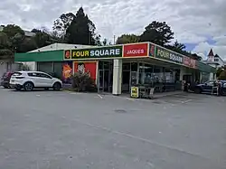 Jaques Four Square supermarket | |
| Nickname: The little town of lights[1] | |
| Coordinates: 36°9′40″S 174°26′37″E / 36.16111°S 174.44361°E | |
| Country | New Zealand |
| Region | Northland Region |
| District | Kaipara District |
| Ward | Kaiwaka-Mangawhai Ward |
| Electorates | |
| Government | |
| • Territorial Authority | Kaipara District Council |
| • Regional council | Northland Regional Council |
| Area | |
| • Total | 7.23 km2 (2.79 sq mi) |
| Population (June 2023)[3] | |
| • Total | 880 |
| • Density | 120/km2 (320/sq mi) |
Kaiwaka is a small town in the Kaipara District, New Zealand. It is situated on State Highway 1 with Brynderwyn 8 kilometers to the north, Whangārei 60 kilometers, Wellsford 20 kilometers to the south and Mangawhai Heads is 18 kilometers northeast of Kaiwaka. It has a primary school that opened in 1871.
References
- ↑ "2009 : 150 years of Kaiwaka, the little town of lights (record)". National Library of New Zealand. 2009.
- ↑ "ArcGIS Web Application". statsnz.maps.arcgis.com. Retrieved 9 May 2022.
- ↑ "Subnational population estimates (RC, SA2), by age and sex, at 30 June 1996-2023 (2023 boundaries)". Statistics New Zealand. Retrieved 25 October 2023. (regional councils); "Subnational population estimates (TA, SA2), by age and sex, at 30 June 1996-2023 (2023 boundaries)". Statistics New Zealand. Retrieved 25 October 2023. (territorial authorities); "Subnational population estimates (urban rural), by age and sex, at 30 June 1996-2023 (2023 boundaries)". Statistics New Zealand. Retrieved 25 October 2023. (urban areas)