Jeffersonville, Indiana
Jeffersonville, Indiana | |
|---|---|
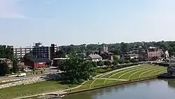 Skyline of Jeffersonville | |
| Nickname: Jeff | |
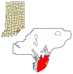 Location of Jeffersonville in Clark County, Indiana | |
| Coordinates: 38°17′44″N 85°43′53″W / 38.29556°N 85.73139°W | |
| Country | United States |
| State | Indiana |
| County | Clark |
| Established | 1801 |
| Area | |
| • Total | 34.35 sq mi (88.97 km2) |
| • Land | 34.08 sq mi (88.26 km2) |
| • Water | 0.28 sq mi (0.71 km2) |
| Elevation | 446 ft (136 m) |
| Population | |
| • Total | 49,447 |
| • Density | 1,451.04/sq mi (560.26/km2) |
| Census | |
| Time zone | UTC−5 (EST) |
| • Summer (DST) | UTC−4 (EDT) |
| ZIP codes | 47130, 47131, and 47199 |
| Area code(s) | 812 & 930 |
| FIPS code | 18-38358[3] |
| GNIS feature ID | 0436979[4] |
| Website | cityofjeff.net |
Jeffersonville is a city of Clark County in the state of Indiana, United States.
References
- ↑ "2020 U.S. Gazetteer Files". United States Census Bureau. Retrieved March 16, 2022.
- ↑ "QuickFacts: Jeffersonville city, Indiana". United States Census Bureau. Retrieved October 24, 2023.
- ↑ "U.S. Census website". United States Census Bureau. Retrieved January 31, 2008.
- ↑ "US Board on Geographic Names". United States Geological Survey. October 25, 2007. Retrieved January 31, 2008.