Interstate 57
Interstate 57 | |||||||||
|---|---|---|---|---|---|---|---|---|---|
 | |||||||||
| Route information | |||||||||
| Maintained by MoDOT and IDOT | |||||||||
| Length | 386.12 mi[1] (621.40 km) | ||||||||
| NHS | Entire route | ||||||||
| Major junctions | |||||||||
| South end |   I-55 / US 60 in Sikeston, MO | ||||||||
| |||||||||
| North end |  I-94 in Chicago, IL | ||||||||
| Location | |||||||||
| Country | United States | ||||||||
| States | Missouri, Illinois | ||||||||
| Counties | MO: Scott, Mississippi IL: Alexander, Pulaski, Union, Johnson, Williamson, Franklin, Jefferson, Marion, Fayette, Clay, Effingham, Shelby, Cumberland, Coles, Douglas, Champaign, Ford, Iroquois, Kankakee, Will, Cook | ||||||||
| Highway system | |||||||||
Illinois State Highway System
| |||||||||




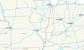
Interstate 57 is an Interstate Highway in the United States. It goes from Miner, Missouri north to Chicago, Illinois. The route is 386.12 miles (621.40 km) long.[1]
References
- 1 2 Staff (October 31, 2002). "Table 1: Main Routes of the Dwight D. Eisenhower National System of Interstate and Defense Highways as of October 31, 2002". Federal Highway Administration. Retrieved July 13, 2006.
 Primary Interstate Highways | |
|---|---|
| Signed | |
| Unsigned | |
| Lists | |
Major Interstates highlighted | |