Immokalee, Florida
Immokalee, Florida | |
|---|---|
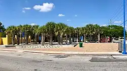 Immokalee Zocalo Public Plaza | |
| Etymology: Mikasuki: Immokalee (your home) | |
 Location in Collier County and the state of Florida | |
| Coordinates: 26°25′07″N 81°25′02″W / 26.41861°N 81.41722°W | |
| Country | United States |
| State | Florida |
| County | Collier |
| Area | |
| • Total | 23.29 sq mi (60.32 km2) |
| • Land | 22.72 sq mi (58.85 km2) |
| • Water | 0.57 sq mi (1.48 km2) 2.5% |
| Elevation | 33 ft (10 m) |
| Population (2020) | |
| • Total | 24,557 |
| • Density | 1,080.81/sq mi (417.30/km2) |
| Time zone | UTC-5 (Eastern (EST)) |
| • Summer (DST) | UTC-4 (EDT) |
| ZIP codes | 34142–34143 |
| Area code | 239 |
| FIPS code | 12-33250[2] |
| GNIS feature ID | 284474[3] |
Immokalee (/ɪˈmɒk(ə)li/ ih-MOK-(ə)-lee) is an unincorporated community and census-designated place in Collier County, Florida, United States. The population was 24,557 at the 2020 census. It is part of the Naples–Marco Island metropolitan area.
References
- ↑ "2020 U.S. Gazetteer Files". United States Census Bureau. Retrieved October 31, 2021.
- ↑ "U.S. Census website". United States Census Bureau. Retrieved January 31, 2008.
- ↑ U.S. Geological Survey Geographic Names Information System: Immokalee
Municipalities and communities of Collier County, Florida, United States | ||
|---|---|---|
County seat: East Naples | ||
| Cities | 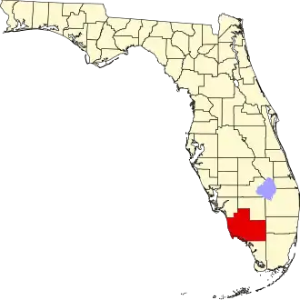 | |
| CDPs |
| |
| Unincorporated communities |
| |
| Ghost towns |
| |