Greater Vancouver
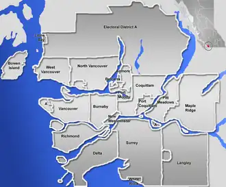
Greater Vancouver, is the third most populous metropolitan area in Canada after the Greater Toronto and Greater Montreal metropolitan areas. The term Greater Vancouver describes an area that is roughly equal with the regional district called Metro Vancouver, though it is older than the 1966 creation of the regional district, which is a political entity. Greater Vancouver is often used to include settlements beyond the boundaries of the Metro Vancouver regional district, but does not generally include wilderness and agricultural areas that are included within Metro Vancouver. Greater Vancouver includes the City of Vancouver, City of Surrey, City of Burnaby, City of Richmond, City of Coquitlam, City of Delta, City of New Westminster, City of Port Coquitlam, City of North Vancouver, and the District Municipality of West Vancouver.
Subdivisions of British Columbia | |||||
|---|---|---|---|---|---|
| Subdivisions |
| ||||
| Communities |
| ||||
| Metro areas and agglomerations |
| ||||
| Regions |
| ||||
| |||||
