Frasertown
Frasertown | |
|---|---|
 | |
| Coordinates: 38°58′S 177°24′E / 38.967°S 177.400°E | |
| Country | New Zealand |
| Region | Hawke's Bay |
| Territorial authority | Wairoa District |
| Ward |
|
| Electorates | |
| Government | |
| • Territorial authority | Wairoa District Council |
| • Mayor of Wairoa | Craig Little[1] |
| • Napier MP | Katie Nimon[2] |
| • Ikaroa-Rāwhiti MP | Cushla Tangaere-Manuel[3] |
| Area | |
| • Total | 1.36 km2 (0.53 sq mi) |
| Population (June 2023)[5] | |
| • Total | 270 |
| • Density | 200/km2 (510/sq mi) |
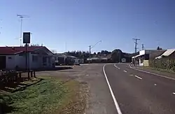
Frasertown is a small settlement in the Wairoa District, North Island. It is located 8 kilometers west of Wairoa on State Highway 38 and has got a primary school in the settlement.
References
- ↑ "RESULTS for Wairoa District Council Local Election 2025". Wairoa District Council. 17 October 2025.
- ↑ "Napier - Official Result". Electoral Commission. 1 August 2025.
- ↑ "Ikaroa-Rāwhiti – Official Result". New Zealand Electoral Commission. Retrieved 28 July 2025.
- ↑ Cite error: The named reference
Areawas used but no text was provided for refs named (see the help page). - ↑ "Subnational population estimates (RC, SA2), by age and sex, at 30 June 1996-2023 (2023 boundaries)". Statistics New Zealand. Retrieved 25 October 2023. (regional councils); "Subnational population estimates (TA, SA2), by age and sex, at 30 June 1996-2023 (2023 boundaries)". Statistics New Zealand. Retrieved 25 October 2023. (territorial authorities); "Subnational population estimates (urban rural), by age and sex, at 30 June 1996-2023 (2023 boundaries)". Statistics New Zealand. Retrieved 25 October 2023. (urban areas)