Bronxville, New York
Bronxville, New York | |
|---|---|
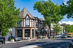 Downtown Bronxville (2025) | |
 Location of Bronxville, New York | |
| Coordinates: 40°56′24″N 73°49′34″W / 40.94000°N 73.82611°W | |
| Country |  United States |
| State |  New York |
| County |  Westchester |
| Town | Eastchester |
| Settled | 1666 |
| Incorporated | 1898 |
| Government | |
| • Mayor | Mary C. Marvin (R)[1] |
| Area | |
| • Total | 0.97 sq mi (2.52 km2) |
| • Land | 0.97 sq mi (2.52 km2) |
| • Water | 0.00 sq mi (0.00 km2) |
| Elevation | 92 ft (28 m) |
| Population (2020) | |
| • Total | 6,656 |
| • Density | 6,847.74/sq mi (2,642.69/km2) |
| Time zone | UTC−5 (Eastern (EST)) |
| • Summer (DST) | UTC−4 (EDT) |
| ZIP Code | 10708 |
| Area code | 914 |
| FIPS code | 36-08532 |
| GNIS feature ID | 0944824 |
| Website | www |
Bronxville is a village in Westchester County, New York, located about 15 miles (24 km) north of midtown Manhattan.[3] It is part of the town of Eastchester. As of the 2020 U.S. census, Bronxville had a population of 6,656.[4]
References
- ↑ "Mayor; Village of Bronxville Election Information March 20, 2007 Election". smartvoter.org. Archived from the original on March 4, 2016. Retrieved February 24, 2026.
- ↑ "ArcGIS REST Services Directory". United States Census Bureau. Retrieved September 20, 2022.
- ↑ Bronxville, NY to Manhattan, NY Archived 2020-12-04 at the Wayback Machine. Retrieved 2010-03-20
- ↑ "Profile of General Population and Housing Characteristics: 2020 Demographic Profile Data (DP-1): Bronxville village, New York". United States Census Bureau. Retrieved March 10, 2024.
Municipalities and communities of Westchester County, New York, United States | ||
|---|---|---|
| Cities | 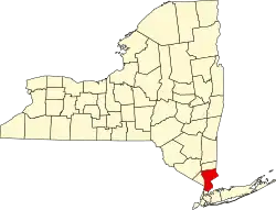 | |
| Towns | ||
| Villages | ||
| CDPs |
| |
| Other hamlets |
| |
| Footnotes | ‡This populated place also has portions in an adjacent county or counties | |