Beachlands, New Zealand
Beachlands | |
|---|---|
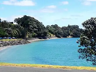 Sunkist Bay in Beachlands, New Zealand | |
| Coordinates: 36°53′S 175°00′E / 36.883°S 175.000°E | |
| Country | New Zealand |
| City | Auckland |
| Local authority | Auckland Council |
| Electoral ward | Franklin ward |
| Local board | Franklin Local Board |
| Established | 1920s |
| Area | |
| • Land | 882 ha (2,179 acres) |
| Population (June 2022)[2] | |
| • Total | 7,610 |
| Ferry terminal(s) | Pine Harbour Marina |
| (Waitematā Harbour), Waiheke Island | ||
| (Tamaki Strait), Howick |
  Beachlands   |
Maraetai |
| Whitford | Clevedon |
Beachlands is an outer suburb of Auckland. It was established in the 1920s. The development has increased from the 1950s, which makes it a beach holiday destination. It has a primary school, and its nearest high school is at Howick College or Botany Downs Secondary College.
References
- ↑ "ArcGIS Web Application". statsnz.maps.arcgis.com. Retrieved 9 August 2022.
- ↑ "Population estimate tables - NZ.Stat". Statistics New Zealand. Retrieved 25 October 2022.