Vizianagaram district
Vizianagaram district | |
|---|---|
District of Andhra Pradesh | |
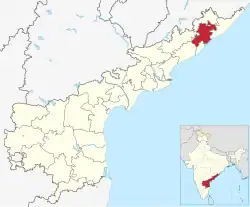 Location of Vizianagaram district in Andhra Pradesh | |
| Country | India |
| State | Andhra Pradesh |
| Headquarters | Vizianagaram |
| Tehsils | 34[1] |
| Government | |
| • District collector | Dr.M.Hari Jawaharlal |
| • Lok Sabha constituencies | Araku, Vizianagaram, Vishakapatnam |
| • Vidhan Sabha constituencies | 09 |
| Area | |
| • District of Andhra Pradesh | 6,539 km2 (2,525 sq mi) |
| Population (2011) | |
| • District of Andhra Pradesh | 2,344,474 |
| • Density | 360/km2 (930/sq mi) |
| • Urban | 20.94% |
| Demographics | |
| • Literacy | 59.49% |
| • Sex ratio | 1016 |
| Vehicle registration | AP-35 (former) AP–39 (from 30 January 2019)[2] |
| Major highways | NH-16 |
| Coordinates | 18°12′N 83°24′E / 18.200°N 83.400°E |
| Website | Official website |
Vizianagaram district is one of the thirteen districts in the Indian state of Andhra Pradesh.[3][4] The headquarters is Vizianagaram.
The French defeated and ended the rule of the Nizam in 1753. These districts were then part of French India.
Related pages
References
- ↑ "District – Guntur". Andhra Pradesh Online Portal. Archived from the original on 28 April 2015. Retrieved 23 August 2014.
- ↑ "New 'AP 39' code to register vehicles in Andhra Pradesh launched". The New Indian Express. Vijayawada. 31 January 2019. Archived from the original on 28 July 2019. Retrieved 9 June 2019.
- ↑ "Srikakulam | Andhra Pradesh | DISTRICTS OF INDIA". districts.nic.in. Archived from the original on 1 June 2019. Retrieved 11 May 2019.
- ↑ "Population of AP districts(2011)" (PDF). ap.gov.in. p. 14. Archived from the original (PDF) on 12 November 2013. Retrieved 25 May 2014.