Tarn (river)
| Tarn | |
|---|---|
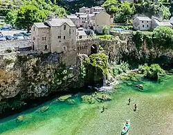 The Tarn in Saint-Chély-du-Tarn, Gorges du Tarn Causses | |
 | |
| Location | |
| Country | France |
| Physical characteristics | |
| Source | Mont Lozère |
| - location | Cévennes, France |
| - coordinates | 44°24′53″N 3°48′54″E / 44.41472°N 3.81500°E |
| - elevation | 1,550 m (5,090 ft) |
| Mouth | Garonne |
| - location | Moissac, France |
| - coordinates | 44°05′10″N 1°02′33″E / 44.086111°N 1.0425°E |
| Length | 380 km (240 mi) |
| Basin size | 15,700 km2 (6,100 sq mi) |
| Discharge | |
| - average | 140 m3/s (4,900 cu ft/s) |
| Basin features | |
| Progression | Garonne→ Atlantic Ocean |
The Tarn is a river in southern France, tributary of the Garonne river. The Tarn and Tarn-et-Garonne departments are named after this river.
Geography
The Tarn river has a length of 380.6 km (236.5 mi) and a drainage basin with an area of 15,700 km2 (6,062 sq mi).[1]
Its average yearly discharge (volume of water which passes through a section of the river per unit of time) is 233 m3/s (8,200 cu ft/s) at Moissac, near the confluence with the Garonne, in the Tarn-et-Garonne department for a period of 57 years.[2]
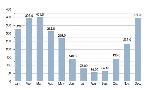
Average monthly discharge (m3/s) at Moissac
Course
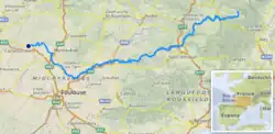
The source of the Tarn is on the Mont Lozère, in the Cévennes, southeastern Massif Central, in the commune of Le Pont-de-Montvert, Lozère department, at an altitude of about 1,560 m (5,118 ft).[3]
The Tarn flows to the southwest, in general, and passes through the following regions, departments and communes:
- Occitanie region
- Lozère: Le Pont-de-Montvert, Sainte-Enimie
- Aveyron: Millau, Saint-Rome-de-Tarn
- Tarn: Albi, Gaillac, Lisle-sur-Tarn, Rabastens, Saint-Sulpice-la-Pointe
- Haute-Garonne: Bessières, Buzet-sur-Tarn, Villemur-sur-Tarn
- Tarn-et-Garonne: Montauban, Lafrançaise, Moissac
The Tarn river flows through a total of 104 communes.[1]
Finally, it flows, as a right tributary into the Garonne near Moissac, in the Tarn-et-Garonne department, at 23 m (75 ft) of altitude.[4]
Main tributaries
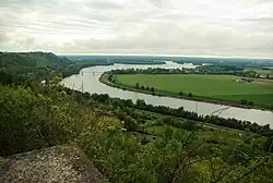
The main tributaries, with a length greater than 25 km, of the Tarn are:
|
Left tributaries:
|
|
Right tributaries: |
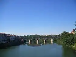
Gallery
Related pages
References
- 1 2 "Le Tarn (O---0100)" (in French). SANDRE - Portail national d'accès aux référentiels sur l'eau. Archived from the original on 22 May 2015. Retrieved 30 May 2014.
- ↑ "Le Tarn à Moissac" (in French). Banque Hydro. Archived from the original on 29 July 2017. Retrieved 13 July 2017.
- ↑ "Source du Tarn" (in French). Géoportail. Retrieved 31 May 2014.
- ↑ "Confluence du Tarn" (in French). Géoportail. Retrieved 31 May 2014.
- ↑ "Le Tarnon (O30-0400)" (in French). SANDRE - Portail national d'accès aux référentiels sur l'eau. Archived from the original on 3 December 2013. Retrieved 31 May 2014.
- ↑ "La Jonte (O31-0400)" (in French). SANDRE - Portail national d'accès aux référentiels sur l'eau. Archived from the original on 2 June 2012. Retrieved 31 May 2014.
- ↑ "La Dourbie (O33-0400)" (in French). SANDRE - Portail national d'accès aux référentiels sur l'eau. Archived from the original on 3 March 2016. Retrieved 31 May 2014.
- ↑ "Le Cernon (O34-0400)" (in French). SANDRE - Portail national d'accès aux référentiels sur l'eau. Archived from the original on 3 March 2016. Retrieved 31 May 2014.
- ↑ "Le Dourdou de Camarès (O35-0400)" (in French). SANDRE - Portail national d'accès aux référentiels sur l'eau. Archived from the original on 6 June 2012. Retrieved 31 May 2014.
- ↑ "Le Rance (O37-0400)" (in French). SANDRE - Portail national d'accès aux référentiels sur l'eau. Archived from the original on 3 March 2016. Retrieved 31 May 2014.
- ↑ "L'Agout (O4--0250)" (in French). SANDRE - Portail national d'accès aux référentiels sur l'eau. Archived from the original on 3 March 2016. Retrieved 31 May 2014.
- ↑ "La Muze (O34-0430)" (in French). SANDRE - Portail national d'accès aux référentiels sur l'eau. Archived from the original on 3 March 2016. Retrieved 31 May 2014.
- ↑ "L'Alrance (O36-0400)" (in French). SANDRE - Portail national d'accès aux référentiels sur l'eau. Archived from the original on 6 December 2015. Retrieved 31 May 2014.
- ↑ "Le Tescou (O49-0430)" (in French). SANDRE - Portail national d'accès aux référentiels sur l'eau. Archived from the original on 3 March 2016. Retrieved 31 May 2014.
- ↑ "L'Aveyron (O5--0250)" (in French). SANDRE - Portail national d'accès aux référentiels sur l'eau. Archived from the original on 3 March 2016. Retrieved 31 May 2014.
- ↑ "Le Lemboulas (O59-0400)" (in French). SANDRE - Portail national d'accès aux référentiels sur l'eau. Retrieved 31 May 2014.
Other websites

- (in French) Banque Hydro - Banque Hydro - Station O5901010 - Le Tarn à Moissac (Synthèse) Archived 2015-02-19 at the Wayback Machine
- (in German) Die Cevennen: Der Fluss Tarn und die Gorges du Tarn
- Office of Tourisme Gorges du Tarn - Grand Causses - Lozère Archived 2011-04-11 at the Wayback Machine
- River Tarn (and the Tarn ‘Ring’) Archived 2014-10-29 at the Wayback Machine