San Cristóbal de La Laguna
San Cristóbal de La Laguna | |
|---|---|
Municipality and city | |
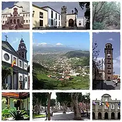 Clockwise from top: University of La Laguna, Shrine of Cristo de La Laguna, Forests, Cathedral of La Laguna, Panoramic city, Iglesia de la Concepción, Consejo Consultivo de Canarias, Plaza del Adelantado and city council. | |
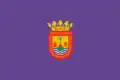 Flag 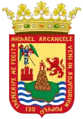 Coat of arms | |
| Nicknames: "La Ciudad de los Adelantados", "La Ciudad de Aguere". | |
Location of San Cristóbal de La Laguna | |
| Coordinates: 28°29′07″N 16°19′00″W / 28.48528°N 16.31667°W | |
| Country | Spain |
| Autonomous community | Canary Islands |
| Province | Santa Cruz de Tenerife |
| Government | |
| • Mayor | Luis Yeray Gutiérrez (PSOE) |
| Area | |
| • Total | 102.6 km2 (39.6 sq mi) |
| Elevation | 543 m (1,781 ft) |
| Population (2018)[1] | |
| • Total | 155,549 |
| • Density | 1,500/km2 (3,900/sq mi) |
| Time zone | UTC0 (WET) |
| • Summer (DST) | UTC+1 (WEST) |
| Postal code | 38200 |
| Official language(s) | Spanish |
| Website | Official website |
| Criteria | Cultural: (ii), (iv) |
| Reference | 929 |
| Inscription | 1999 (23rd Session) |
| Area | 60.38 ha (149.2 acres) |
| Buffer zone | 23.71 ha (58.6 acres) |
San Cristóbal de La Laguna (commonly known as La Laguna, es) is a city and municipality in the northern part of the island of Tenerife in the Province of Santa Cruz de Tenerife, on the Canary Islands, Spain. It was the former capital of the Canary Islands. The city is the third-most populous city of the archipelago and the second-most populous city of the island.
References
- ↑ Municipal Register of Spain 2018. National Statistics Institute.
Other websites
- Organismo Autónomo de Deportes de La Laguna Archived 18 March 2010 at the Wayback Machine, featuring information about activities, installations, news, etc. (in Spanish)