Rhins
| Rhins | |
|---|---|
 The Rhins in Saint-Cyr-de-Favières | |
| Location | |
| Country |  France |
| Region | Auvergne-Rhône-Alpes |
| Department | Rhône, Loire |
| Municipalities | Amplepuis, Le Coteau, Roanne |
| Physical characteristics | |
| Source | Monts du Beaujolais |
| - location | Ranchal, Rhône |
| - coordinates | 46°8′8″N 4°21′55″E / 46.13556°N 4.36528°E |
| - elevation | 760 km (470 mi) |
| Mouth | Loire |
| - location | Roanne, Loire |
| - coordinates | 46°3′3″N 4°6′33″E / 46.05083°N 4.10917°E |
| - elevation | 265 km (165 mi) |
| Length | 59.8 km (37.2 mi) |
| Basin size | 468 km2 (181 sq mi) |
| Discharge | |
| - location | Saint-Cyr-de-Favières |
| - average | 5.17 m3/s (183 cu ft/s) |
| Basin features | |
| Tributaries | |
| - left | Gand |
| - right | Trambouze |
The Rhins or Reins is a river in central France in the Auvergne-Rhône-Alpes region. It is a right tributary of the Loire river.
Geography
The Rhins river has a length of 59.8 km (37.2 mi), and a drainage basin with an area of 468 km2 (181 sq mi).[1]
Course
The Rhins starts in the Monts du Beaujolais, in the commune of Ranchal, (Rhône department), at an altitude of about 760 m (2,493 ft).[2] From here, the Rhins flows first to the south, then to the west and ends flowing to the northwest.
The Rhins river flows within the Auvergne-Rhône-Alpes region, 2 departments and 21 communes. It flows through the following communes, among others:[1]
- Rhône : Saint-Vincent-de-Reins, Cublize, Amplepuis
- Loire : Saint-Victor-sur-Rhins, Régny, Le Coteau, Roanne
Finally, it flows into the Loire river in the commune of Roanne.[3]
Main tributaries

The main tributaries of the Rhins river are:[1]
|
Left tributaries:
|
|
Right tributaries:
|
Hydrology
Its average yearly discharge (volume of water which passes through a section of the river per unit of time) is 5.17 m3/s (183 cu ft/s) at Saint-Cyr-de-Favières in the Loire department, for the period 1969 - 2017.[4]
Average monthly discharge (m3/s) at Saint-Cyr-de-Favières (1969 - 2017)[4]
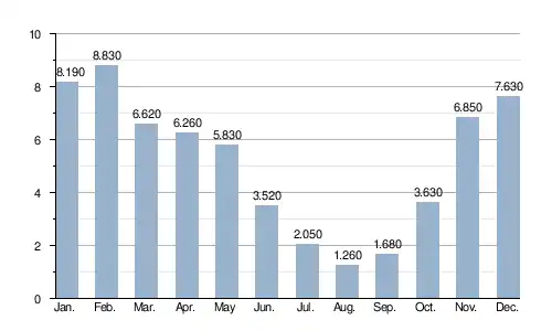
The Rhins is a very irregular small river; it shows typical seasonal changes. The highest levels of the river are in winter and spring, from November to May inclusive, with the highest level in February. They are followed by a rapid fall in the flow during the low water period that goes from late June to early October.
Related pages
References

- 1 2 3 "Rivière Le Rhins (K09-0300)" (in French). SANDRE - Portail national d'accès aux référentiels sur l'eau. Archived from the original on 4 March 2016. Retrieved 14 October 2017.
- ↑ "Source du Rhins" (in French). Géoportail. Retrieved 14 October 2017.
- ↑ "Confluence du Rhins" (in French). Géoportail. Retrieved 14 October 2017.
- 1 2 "Le Rhins à Saint-Cyr-de-Favières (Pont Mordon)" (in French). Banque Hydro. Archived from the original on 29 September 2020. Retrieved 14 October 2017.