Queens County, New Brunswick
Queens | |
|---|---|
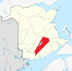 Location within New Brunswick. | |
| Country | Canada |
| Province | New Brunswick |
| Established | 1785 |
| Shire town | Gagetown |
| Area | |
| • Land | 3,681.05 km2 (1,421.26 sq mi) |
| Population (2021)[1] | |
| • Total | 10,998 |
| • Density | 3.0/km2 (8/sq mi) |
| • Change 2016–2021 |  5.0% |
| • Dwellings | 6,854 |
| Time zone | UTC−4 (AST) |
| • Summer (DST) | UTC−3 (ADT) |
| Area code | 506 |

Wikimedia Commons has media related to Queens County, New Brunswick.
Queens County (2021 population 10,998[1]) is located in central New Brunswick, Canada. The county shire town is the village of Gagetown.
Geography
The Saint John River and Grand Lake are major landmarks in the county. Coal mining is a major industry in the Minto area. Forestry and mixed farming are found throughout the rest of the county. The CFB Gagetown military training area takes in a large portion of the western part of the county.
Census subdivisions
Communities
There are four municipalities within Queens County (listed by 2021 population):[2]
| Official Name | Designation | Area km2 | Population | Parish |
|---|---|---|---|---|
| Minto | Village | 31.36 | 2,234 | Canning |
| Chipman | Village | 19.00 | 1,201 | Chipman |
| Gagetown | Village | 49.32 | 787 | Gagetown |
| Cambridge-Narrows | Village | 106.79 | 715 | Cambridge |
- Part of Minto lies within Sunbury County, but since most of it is in Queens County, Statistics Canada considers it as part of Queens.
Parishes
The county is subdivided into ten parishes (listed by 2021 population):[2] The parishes do not include the municipalities within them.
| Official Name | Area km2 | Population | Municipalities | Unincorporated communities |
|---|---|---|---|---|
| Canning | 173.25 | 1,028 | Minto (village) | Back Road / Canning / Clarks Corners / Douglas Harbour / Flowers Cove / Lake Road / Maquapit Lake / Newcastle Center / Newcastle Centre / Newcastle Creek / Princess Park / Scotchtown / Sunnyside Beach / Sypher Cove / Upper Gagetown / Wuhr's Beach Road |
| Chipman | 483.45 | 853 | Chipman (village) | Briggs Corner / Bronson / Bronson Settlement / Camp Wegesegum / Castaway / Coal Creek / Dufferin / Fowlers Corner / Gaspereau Forks / Harley Road / Iron Bound Cove / Kings Mines / Leckey Road / Midland / Redbank / Salmon Creek / Salmon River / The Ridge / Upper Gaspereau |
| Waterborough | 443.16 | 903 | Cox Point / Cumberland Bay / Cumberland Point / Grant Settlement / Mill Cove / New Dominion Road / Pangburn / Rees / The Range / Union Settlement / Waterborough / Youngs Cove | |
| Petersville | 589.95 | 710 | Bayard / Blagdon / Clarendon / Enniskillen / Fowlers Corners / Petersville / Welsford / Wirral / Wirral Station / Wirral-Enniskillen | |
| Cambridge | 113.17 | 684 | Cambridge-Narrows | Cherry Hill / Jemseg / Lower Cambridge / Lower Jemseg / Robertson Point / Scovil / Whites Cove |
| Johnston | 360.87 | 638 | Annidale / Bagdad / Canaan Rapids / Chambres Corner / Codys / Coles Island / Highfield / Johnston / Long Creek / Partridge Valley / Phillipstown / Salmon Creek / Smith Corner / Thornetown / Washademoak / Waterloo Corner / Youngs Cove Road | |
| Wickham | 160.54 | 409 | Bald Hill / Belyeas Cove / Big Cove / Carpenter / Crafts Cove / Henderson Settlement / London Settlement / MacDonalds Point / Shannon / Wickham | |
| Gagetown | 234.58 | 324 | Gagetown (village) | Coytown / Mill Road / Upper Gagetown |
| Hampstead | 212.39 | 288 | Central Hampstead / Elm Hill / Hampstead / McAlpines / Pleasant Villa / Quarries / Queenstown | |
| Brunswick | 703.20 | 224 | Alward / Brookvale / Brunswick / Canaan Forks / Cherryvale / Forks Stream / Hunters Home / New Canaan |
Demographics
Population
Canada census – Queens community profile
| 2021 | 2016 | 2011 | |
|---|---|---|---|
| Population | 10,998 (+5.0% from 2016) | 10,472 (−5.5% from 2011) | 11,086 (−5.3% from 2006) |
| Land area | 3,681.05 km2 (1,421.26 sq mi) | 3,686.05 km2 (1,423.19 sq mi) | 3,681.98 km2 (1,421.62 sq mi) |
| Population density | 3/km2 (7.8/sq mi) | 2.8/km2 (7.3/sq mi) | 3.0/km2 (7.8/sq mi) |
| Median age | 56.4 (M: 56, F: 56.8) | 54.4 (M: 54.2, F: 54.6) | 51.3 (M: 51.0, F: 51.7) |
| Private dwellings | 5,135 (total) | 7,289 (total) | 7,337 (total) |
| Median household income | $48,539 | $45,555 |
| Year | Pop. | ±% |
|---|---|---|
| 1991 | 12,519 | — |
| 1996 | 12,470 | −0.4% |
| 2001 | 11,862 | −4.9% |
| 2006 | 11,708 | −1.3% |
| 2011 | 11,086 | −5.3% |
| 2016 | 10,472 | −5.5% |
| 2021 | 10,998 | +5.0% |
| [5][6][7][1] | ||
Language
| Canada Census Mother Tongue - Queens County, New Brunswick[5][6][7][8] | ||||||||||||||||||
|---|---|---|---|---|---|---|---|---|---|---|---|---|---|---|---|---|---|---|
| Census | Total | English |
French |
English & French |
Other | |||||||||||||
| Year | Responses | Count | Trend | Pop % | Count | Trend | Pop % | Count | Trend | Pop % | Count | Trend | Pop % | |||||
2021 |
10,810 |
10,170 | 5.3% |
94.08% | 385 |  13.5% |
3.56% | 70 | 75.0% |
0.65% | 170 | 13.3% |
1.57% | |||||
2016 |
10,290 |
9,655 | 5.3% |
93.83% | 445 | 11.0% |
4.32% | 40 |  |
0.39% | 150 | 15.4% |
1.46% | |||||
2011 |
10,865 |
10,195 | 2.9% |
93.83% | 500 | 18.0% |
4.60% | 40 | 27.3% |
0.37% | 130 | 56.7% |
1.20% | |||||
2006 |
11,460 |
10,495 | 3.4% |
91.58% | 610 | 17.3% |
5.32% | 55 | 37.5% |
0.48% | 300 | 46.3% |
2.62% | |||||
2001 |
11,635 |
10,870 | 4.7% |
93.43% | 520 | 23.0% |
4.47% | 40 | 0.0% |
0.34% | 205 | 57.7% |
1.76% | |||||
1996 |
12,255 |
11,410 | n/a | 93.10% | 675 | n/a | 5.51% | 40 | n/a | 0.37% | 130 | n/a | 1.01% | |||||
Transportation
Major Highways
 Route 2 (TCH)
 Route 7
 Route 10
 Route 101
 Route 102
 Route 105
 Route 112
 Route 116
 Route 123
 Route 690
 Route 695
 Route 705
 Route 710
 Route 715
References
- 1 2 3 4 "Population and dwelling counts: Canada and census divisions". Statistics Canada. February 9, 2022. Retrieved April 3, 2022.
- 1 2 3 "2021 Community Profiles". 2021 Canadian census. Statistics Canada. February 4, 2022. Retrieved 2022-04-27.
- ↑ "2016 Community Profiles". 2016 Canadian census. Statistics Canada. August 12, 2021. Retrieved 2019-09-26.
- ↑ "2011 Community Profiles". 2011 Canadian census. Statistics Canada. March 21, 2019. Retrieved 2014-05-02.
- 1 2 Statistics Canada: 1996, 2001, 2006, 2011 census
- 1 2 2011 Statistics Canada Census Profile: Queens County, New Brunswick
- 1 2 "Census Profile, 2016 Census Queens, County [Census division], New Brunswick". Statistics Canada. Retrieved September 26, 2019.
- ↑ "Census Profile, 2021 Census Queens, County [Census division], New Brunswick". Statistics Canada. Retrieved April 13, 2025.
Other websites
45°50′N 66°00′W / 45.833°N 66.000°W