Pailin province
Pailin Province
ប៉ៃលិន | |
|---|---|
Province | |
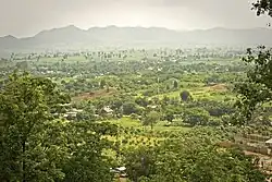 Pailin countryside from Phnom Yat | |
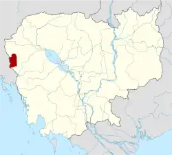 Map of Cambodia highlighting Pailin | |
| Coordinates: 12°51′02″N 102°36′34″E / 12.85056°N 102.60944°E | |
| Country |  Cambodia |
| Founded | 1909 |
| City–municipality | 31 July 1997 |
| Province | 22 December 2008 |
| Capital | Pailin Municipality |
| Area | |
| • Total | 803 km2 (310 sq mi) |
| Population (2019 census)[1] | |
| • Total |  71,600 |
| • Density | 89/km2 (230/sq mi) |
| Time zone | UTC+7 (ICT) |
| Dialing code | +855 |
| ISO 3166 code | KH-24 |
| Districts | 2 |
Pailin is a province in Cambodia. The capital is Pailin Municipality. Its at the northern edge of the Cardamom Mountains near the border of Thailand.[2] This province is surrounded by Battambang Province.
Besides Pailin Municipality the only other district is Sala Krau.
References
- ↑ "General Population Census of the Kingdom of Cambodia 2019". National Institute of Statistics. Ministry of Planning. June 2019. Retrieved 12 August 2019.
- ↑ "Pailin Province". Official Tourism website of Pailin. Archived from the original on December 20, 2016. Retrieved December 4, 2016.