Osceola, Iowa
Osceola, Iowa | |
|---|---|
Osceola Commercial Historic District | |
 Location of Osceola, Iowa | |
| Coordinates: 41°01′46″N 93°47′03″W / 41.02944°N 93.78417°W | |
| Country | United States |
| State | Iowa |
| County | Clarke |
| Area | |
| • Total | 7.60 sq mi (19.68 km2) |
| • Land | 7.26 sq mi (18.81 km2) |
| • Water | 0.33 sq mi (0.86 km2) |
| Elevation | 1,119 ft (341 m) |
| Population (2024) | |
| • Total | 5,585 |
| • Density | 745.56/sq mi (287.85/km2) |
| Time zone | UTC-6 (Central (CST)) |
| • Summer (DST) | UTC-5 (CDT) |
| ZIP code | 50213 |
| Area code | 641 |
| FIPS code | 19-59835 |
| GNIS feature ID | 468477[2] |
| Website | www |
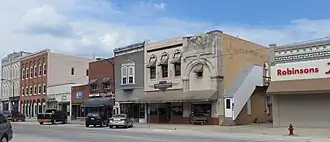
Osceola is a city in the state of Iowa, in the United States.
- ↑ "2020 U.S. Gazetteer Files". United States Census Bureau. Retrieved March 16, 2022.
- 1 2 U.S. Geological Survey Geographic Names Information System: Osceola, Iowa