Ontario Highway 400
Highway 400 | ||||
|---|---|---|---|---|
| Toronto–Barrie Highway[1] | ||||
 | ||||
| Route information | ||||
| Maintained by Ministry of Transportation of Ontario | ||||
| Length | 226 km[2] (140 mi) | |||
| History | Opened December 1, 1951 – July 1, 1952[3] | |||
| Major junctions | ||||
| South end | Maple Leaf Drive – Toronto (continues as Black Creek Drive) | |||
 Highway 401 – Toronto  Highway 407 – Vaughan  Highway 11 – Barrie  Highway 12 – Waubaushene  Highway 124 – Parry Sound | ||||
| North end |  Highway 69 in Carling | |||
| Location | ||||
| Country | Canada | |||
| Province | Ontario | |||
| Major cities | Toronto Barrie Sudbury (future) | |||
| Towns | Parry Sound, Bradford, King | |||
| Highway system | ||||
| ||||
| ||||


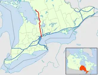
Ontario Highway 400, also called King's Highway 400, is a provincial highway in Ontario, Canada. It runs mostly north and south and is 226 kilometers (140 miles) long. It goes between Toronto and Carling.
References
- ↑ "Toronto–Barrie Highway". The Maple Leaf. October 2, 1944. Retrieved June 23, 2015.
- ↑ Ministry of Transportation of Ontario (2008). "Annual Average Daily Traffic (AADT) counts". Government of Ontario. Archived from the original on July 6, 2011. Retrieved December 27, 2011.
- ↑ Shragge 1984, pp. 89–92.