Mongolian Plateau
The Mongolian Plateau or Altai Plateau is a plateau in East Asia. This plateau covers about 3,200,000 square kilometers (1,200,000 sq mi). In the east of the plateau, there are the Greater Hinggan Mountains. There are the Yin Mountains to the south. There are the Altai Mountains to the west. There are the Sayan and Khentii mountains to the north of this region.[1] The plateau has the Gobi Desert and many dry steppe areas. It has an elevation of about 1,000 to 1,500 meters (3,300 to 4,900 ft). The lowest point is in the Hulunbuir. The highest point is in the Altai Mountains.[1]
All of Mongolia is part of the plateau. The plateau also has parts of China and Russia. Inner Mongolia and part of the Dzungarian basin in Xinjiang have the Chinese parts of the plateau. In Russia, the plateau forms Transbaikal, part of Buryatia, and the southern Irkutsk Oblast. The Mongolian Plateau is part of the Mongol heartland.
Geography
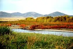
The average elevation of the Mongolian Plateau is from 915 to 1,525 meters (3,002 to 5,003 ft) above sea level.[2] The highest point in the plateau is found in Tavan Bogd. Tavan Bogd is 4,374 meters (14,350 ft) above sea level.[3]
Related pages
References
- 1 2 Zhang, Xueyan; Hu, Yunfeng; Zhuang, Dafang; Qi, Yongqing; Ma, Xin (2009). "NDVI spatial pattern and its differentiation on the Mongolian Plateau". Journal of Geographical Sciences. 19 (4). Springer-Verlag: 405. Bibcode:2009JGSci..19..403Z. doi:10.1007/s11442-009-0403-7.
- ↑ "Mongolian Plateau | Map, Location, & Facts | Britannica". www.britannica.com.
- ↑ Centre, UNESCO World Heritage. "Highlands of Mongol Altai". UNESCO World Heritage Centre.
Other websites
- John, Ranjeet; et al. (2013). "Vegetation response to extreme climate events on the Mongolian Plateau from 2000 to 2010". Environmental Research Letters. 8 (3). IOP Publishing: 035033. Bibcode:2013ERL.....8c5033J. doi:10.1088/1748-9326/8/3/035033.
{{cite journal}}: CS1 maint: article number as page number (link) - "Mongolian Plateau region, Mongolia and China". Britannica.com. Encyclopædia Britannica. 2 August 1999. Retrieved 26 November 2016.