Minnesota's 4th congressional district
| Minnesota's 4th congressional district | |||
|---|---|---|---|
Interactive map of district boundaries since January 3, 2023 | |||
| Representative |
| ||
| Area | 202[1] sq mi (520 km2) | ||
| Distribution |
| ||
| Population (2024) | 708,464[3] | ||
| Median household income | $84,731[4] | ||
| Ethnicity |
| ||
| Cook PVI | D+18[5] | ||
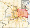
 THIS govtrack.us MAP, is a useful representation of the 4th CD's borders, based on Google Maps. |
Minnesota's 4th congressional district covers nearly all of Ramsey County and part of Washington County. It includes all of St. Paul and most of its northern and eastern suburbs, including Woodbury, Blaine, Roseville, and Maplewood. The district is solidly Democratic. It is currently represented by Betty McCollum of the Minnesota Democratic-Farmer-Labor Party (DFL).
References
- ↑ "Minnesota congressional districts by urban and rural population and land area" (PDF). US Census Bureau. 2000. Retrieved 2007-04-02.
- ↑ "Congressional Districts Relationship Files (state-based)". www.census.gov. US Census Bureau Geography. Retrieved 10 April 2018.
- ↑ "My Congressional District". www.census.gov. Center for New Media & Promotion (CNMP), US Census Bureau. Retrieved 14 September 2025.
- ↑ "My Congressional District". www.census.gov. Center for New Media & Promotion (CNMP), US Census Bureau. Retrieved 2025-09-14.
- ↑ "2025 Cook PVI℠: District Map and List (119th Congress)". Cook Political Report. April 3, 2025. Retrieved 2025-04-05.