Minnesota's 2nd congressional district
| Minnesota's 2nd congressional district | |||
|---|---|---|---|
Interactive map of district boundaries since January 3, 2023 | |||
| Representative |
| ||
| Area | 3,035[1] sq mi (7,860 km2) | ||
| Distribution |
| ||
| Population (2024) | 746,020[3] | ||
| Median household income | $108,162[4] | ||
| Ethnicity |
| ||
| Cook PVI | D+3[5] | ||
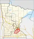
 THIS govtrack.us MAP, is a useful representation of the 2nd CD's borders, based on Google Maps. |
Minnesota's 2nd congressional district covers the south Twin Cities metro area and represents all of Scott, Dakota, and Le Sueur counties. It also represents part of northern and eastern Rice County including the city of Northfield, as well as southern Washington County including the city of Cottage Grove. Lakeville and Eagan are the largest cities in the district.
References
- ↑ "Minnesota congressional districts by urban and rural population and land area" (PDF). US Census Bureau. 2000. Retrieved April 2, 2007.
- ↑ "Congressional Districts Relationship Files (state-based)". www.census.gov. US Census Bureau Geography.
- ↑ "My Congressional District". www.census.gov. Center for New Media & Promotion (CNMP), US Census Bureau.
- ↑ "My Congressional District". www.census.gov. Center for New Media & Promotion (CNMP), US Census Bureau.
- ↑ "2025 Cook PVI℠: District Map and List (119th Congress)". Cook Political Report. Retrieved 2025-04-05.