Massachusetts's 1st congressional district
| Massachusetts's 1st congressional district | |||
|---|---|---|---|
Interactive map of district boundaries since January 3, 2023 | |||
| Representative |
| ||
| Area | 3,101.14 sq mi (8,031.9 km2) | ||
| Distribution |
| ||
| Population (2024) | 779,993 | ||
| Median household income | $75,462[1] | ||
| Ethnicity |
| ||
| Occupation |
| ||
| Cook PVI | D+8[2] | ||
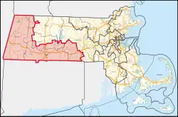
Massachusetts's 1st congressional district is a United States congressional district in the western and central part of Massachusetts. It is the state's largest congressional district by area. It is about one-third of the state and is more rural than other districts. The district includes the cities of Springfield, West Springfield, Pittsfield, Holyoke, Agawam, Chicopee and Westfield.
References
- ↑ "My Congressional District / Massachusetts / District 1". United States Census Bureau. Retrieved September 14, 2025 – via Census.gov.
- ↑ "2025 Cook PVI℠: District Map and List (119th Congress)". Cook Political Report. April 3, 2025. Retrieved 2025-04-05.