Lyndhurst, South Australia
Lyndhurst is a very small town in the remote Outback of the state of South Australia, Australia. It is an important stop for people travelling across the desert on famous unsealed roads.
| Lyndhurst South Australia | |
|---|---|
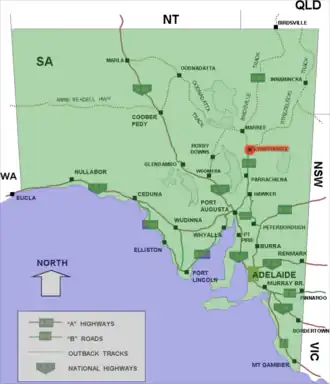 Location of Lyndhurst in South Australia (red) | |
| Coordinates | 30°17′07″S 138°20′51″E / 30.285384°S 138.347511°E |
| Population | 3 (as of 2021) |
| Established | 20 February 1896 (town) 8 February 2001 (locality) |
| Time zone | ACST (UTC+9:30) |
| • Summer (DST) | ACDT (UTC+10:30) |
History
The traditional owners of this land are the Kuyani Aboriginal people.[1] The town started in 1878 as a stop on the Great Northern Railway. This line was planned to go all the way to Darwin, but it only went as far as Alice Springs.
The railway was later famous for carrying the passenger train called The Ghan. Lyndhurst was a freight and rest centre for the railway workers. In 1980, the railway line near Lyndhurst was closed. A new, more modern railway was built far to the west. Today, Lyndhurst is still a small but important stop. Travellers use the Lyndhurst Roadhouse to get fuel, food, and a place to rest before driving further into the remote Outback.
Geography
Lyndhurst is a famous "crossroads" town in the Far North of South Australia. It is where two famous outback tracks meet:
- The Strzelecki Track, which goes north-east to the town of Innamincka.
- The Oodnadatta Track, which goes north to the town of Marree and continues into the deep desert.
The town is on flat, arid (dry) country, which is part of the great Australian desert area. About 5 kilometres (3 miles) north of the town are the Ochre Cliffs. These cliffs have colourful dirt (ochre) that Aboriginal people used for thousands of years to make paint. The weather in Lyndhurst is very hot in the summer and dry for most of the year.
- ↑ "Map of Indigenous Australia". AIATSIS. Retrieved 17 May 2021.