Hopetoun, Victoria
| Hopetoun Victoria | |||||||||
|---|---|---|---|---|---|---|---|---|---|
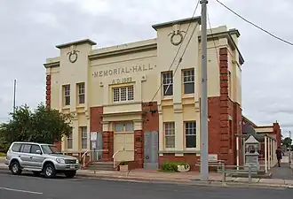 Memorial Hall in Hopetoun, built in 1922 | |||||||||
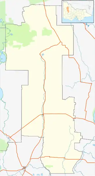  Hopetoun | |||||||||
| Coordinates | 35°43′S 142°21′E / 35.717°S 142.350°E | ||||||||
| Population | 694 (2021 census)[1] | ||||||||
| Postcode(s) | 3396 | ||||||||
| Elevation | 77 m (253 ft)[2] | ||||||||
| Location |
| ||||||||
| LGA(s) | Shire of Yarriambiack | ||||||||
| State electorate(s) | Mildura | ||||||||
| Federal division(s) | Mallee | ||||||||
| |||||||||
Hopetoun is a town in Victoria, Australia. It is the main service town for the Southern Mallee area.[3] Hopetoun is 400 km (249 mi) northwest of Melbourne on the Henty Highway, in the Shire of Yarriambiack. In 2021 census, about 694 people lived there.[1]
History
The first European settlers were Peter McGinnis and George Bell in 1846. They set up a large sheep farm covering 46000 acres on the banks of Lake Corrong.[4]
The town is named after the 7th Earl of Hopetoun. He was the Governor of Victoria from 1889 to 1895 and later became the first Governor-General of Australia.[5] The post office opened on September 12, 1891, when the town was started.[6]
In early 2009, during a heatwave in Australia, Hopetoun had very hot weather. The temperature reached 48.8 °C (119.8 °F), the highest in the country during that heatwave and the hottest ever recorded in Victoria.[7]
On January 27, 2026, a new record was set in Victoria. The temperature reached 48.9 °C (120.0 °F) in both Hopetoun and Walpeup during a strong heatwave, breaking the old record.[8]
Present
The town has a hotel, supermarket (IGA), newsagent, post office, chemist, hairdressers, and a service station. Hopetoun P-12 College is both a primary and secondary school for the area. There also is a Catholic primary school. The town has a fast food cafe and a second-hand shop (op shop). There is a hospital with urgent care, a ward for serious illness, and a home for older people who need care. Hopetoun Airport is nearby and serves the town.
Local places to visit include Wyperfeld National Park, Yarriambiack Creek, and Lake Coorong.
Hopetoun has a football and netball club called the Southern Mallee Thunder, which also has players from nearby towns Rainbow, Jeparit, and Beulah. The teams play in the Wimmera Football Netball League. The town also has a golf course, lawn bowls, cricket, tennis, basketball, and many other sports and activities for all ages.
Golfers play at the Hopetoun Golf Club on Rainbow Road.[9]
Geography and climate
Hopetoun has a cold semi-arid climate, which means hot summers and cool winters.[10] The most rain in one day was 75.0 mm (2.95 in) on January 12, 2011. The highest temperature recorded was 48.9 °C (120.0 °F) on January 27, 2026, and the lowest was −6.4 °C (20.5 °F) on June 15, 2006.
| Climate data for Hopetoun Airport 35°43′S 142°22′E / 35.72°S 142.36°E, 77 m (253 ft) AMSL (2004–2026) | |||||||||||||
|---|---|---|---|---|---|---|---|---|---|---|---|---|---|
| Month | Jan | Feb | Mar | Apr | May | Jun | Jul | Aug | Sep | Oct | Nov | Dec | Year |
| Record high °C (°F) | 48.9 (120.0) |
48.8 (119.8) |
42.1 (107.8) |
39.3 (102.7) |
29.4 (84.9) |
25.7 (78.3) |
25.5 (77.9) |
26.0 (78.8) |
34.6 (94.3) |
39.9 (103.8) |
45.0 (113.0) |
47.9 (118.2) |
48.9 (120.0) |
| Average high °C (°F) | 33.2 (91.8) |
32.0 (89.6) |
28.9 (84.0) |
23.8 (74.8) |
18.9 (66.0) |
15.3 (59.5) |
15.0 (59.0) |
16.9 (62.4) |
20.3 (68.5) |
24.5 (76.1) |
27.9 (82.2) |
30.7 (87.3) |
24.0 (75.1) |
| Average low °C (°F) | 15.5 (59.9) |
14.6 (58.3) |
12.7 (54.9) |
9.0 (48.2) |
5.9 (42.6) |
4.1 (39.4) |
3.2 (37.8) |
3.6 (38.5) |
4.9 (40.8) |
7.6 (45.7) |
10.8 (51.4) |
13.0 (55.4) |
8.7 (47.7) |
| Record low °C (°F) | 5.6 (42.1) |
5.6 (42.1) |
1.0 (33.8) |
−1.7 (28.9) |
−3.2 (26.2) |
−6.4 (20.5) |
−5.0 (23.0) |
−5.3 (22.5) |
−3.6 (25.5) |
−1.4 (29.5) |
−0.1 (31.8) |
3.6 (38.5) |
−6.4 (20.5) |
| Average precipitation mm (inches) | 27.9 (1.10) |
15.6 (0.61) |
15.3 (0.60) |
23.3 (0.92) |
23.8 (0.94) |
25.5 (1.00) |
26.5 (1.04) |
26.4 (1.04) |
26.7 (1.05) |
25.8 (1.02) |
32.6 (1.28) |
26.2 (1.03) |
296.6 (11.68) |
| Average precipitation days (≥ 0.2 mm) | 5.1 | 3.6 | 4.6 | 5.5 | 9.1 | 13.0 | 15.7 | 13.4 | 9.7 | 7.4 | 7.9 | 5.7 | 100.7 |
| Source 1: Bureau of Meteorology (2004–2025)[2] | |||||||||||||
| Source 2: Australian Broadcasting Corporation[8] | |||||||||||||
References

- 1 2 Australian Bureau of Statistics (28 June 2022). "Hopetoun (Vic.)". 2021 Census QuickStats. Retrieved 27 January 2026.
- 1 2 3 4 5 "Hopetoun Airport Climate Statistics (2004-2025)". Bureau of Meteorology. Retrieved January 21, 2026.
- ↑ Brocklebank, Deirdre Heather (2010), Tell tales : memoirs of Hopetoun Victoria 1950s-70 ([Revised edition] ed.), Deirdre Brocklebank, ISBN 978-0-646-54885-2
- ↑ "History of Hopetoun". Hopetoun, Vic. Retrieved 17 June 2026.
- ↑ "HOPETOUN". Adelaide Observer. Vol. L, no. 2, 702. South Australia. 15 July 1893. p. 32. Retrieved 26 August 2019 – via National Library of Australia.
- ↑ Phoenix Auctions History, Post Office List, retrieved 28 January 2021
- ↑ "The exceptional January–February 2009 heatwave in south-eastern Australia" (PDF), Bureau of Meteorology, National Climate Centre, p. 2, 2009-02-12
- 1 2 Miles, Daniel (27 January 2026). "Victorian maximum temperature record broken as heatwave engulfs Australia". ABC News. Australian Broadcasting Corporation. Retrieved 27 January 2026.
- ↑ Golf Select, Hopetoun, retrieved 2009-05-11
- ↑ "Climate classification maps: Köppen - all classes". Bureau of Meteorology. Retrieved January 21, 2026.