Greensboro Urban Loop
Greensboro Urban Loop | |
|---|---|
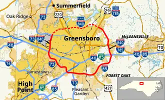 Greensboro Urban Loop in red | |
| Route information | |
| Maintained by NCDOT | |
| Length | 39.5 mi[1] (63.6 km) |
| Existed | 2002–present |
| Component highways | |
| Major junctions | |
| Beltway around Greensboro | |
| |
| Location | |
| Country | United States |
| State | North Carolina |
| Counties | Guilford |
| Highway system | |
| |



The Greensboro Urban Loop is a 39.5-mile (63.6 km) Interstate Highway beltway that encircles Greensboro, North Carolina, United States. The Urban Loop travels I-73, I-85, I-785, I-840, and US 421. It is usually located within Greensboro city limits, though it often crosses the city line. The Urban Loop was completed at January 23, 2023.
References
- ↑ Google (January 26, 2023). "Greensboro Urban Loop" (Map). Google Maps. Google. Retrieved January 26, 2023.