Elgin, North Dakota
Elgin, North Dakota | |
|---|---|
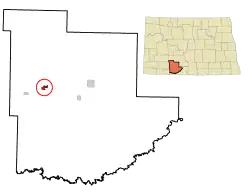 Location of Elgin, North Dakota | |
| Coordinates: 46°24′05″N 101°50′51″W / 46.40139°N 101.84750°W | |
| Country | United States |
| State | North Dakota |
| County | Grant |
| Founded | 1910 |
| Area | |
| • Total | 0.82 sq mi (2.13 km2) |
| • Land | 0.82 sq mi (2.13 km2) |
| • Water | 0.00 sq mi (0.00 km2) |
| Elevation | 2,352 ft (717 m) |
| Population (2020) | |
| • Total | 543 |
| • Estimate (2024) | 524 |
| • Density | 659.78/sq mi (254.89/km2) |
| Time zone | UTC-7 (Mountain (MST)) |
| • Summer (DST) | UTC-6 (MDT) |
| ZIP code | 58533 |
| Area code | 701 |
| FIPS code | 38-23020 |
| GNIS feature ID | 1036020[2] |
| Website | elginnorthdakota.com |
Elgin is a city in Grant County, North Dakota, United States. The population was 543 at the 2020 census.[3]
References
- ↑ "ArcGIS REST Services Directory". United States Census Bureau. Retrieved September 20, 2022.
- 1 2 U.S. Geological Survey Geographic Names Information System: Elgin, North Dakota
- ↑ "Explore Census Data". United States Census Bureau. Retrieved October 22, 2023.