Ceredo, West Virginia
Ceredo, West Virginia | |
|---|---|
Town | |
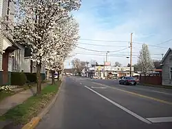 Looking east along U.S. Route 60 from C Street | |
 Flag  Logo | |
 Location of Ceredo in Wayne County, West Virginia. | |
| Coordinates: 38°23′36″N 82°33′37″W / 38.39333°N 82.56028°W | |
| Country | United States |
| State | West Virginia |
| County | Wayne |
| Established | 1857[1] |
| Incorporated | 1866 |
| Area | |
| • Total | 2.04 sq mi (5.29 km2) |
| • Land | 1.31 sq mi (3.40 km2) |
| • Water | 0.73 sq mi (1.89 km2) |
| Elevation | 551 ft (168 m) |
| Population (2020) | |
| • Total | 1,408 |
| • Density | 690.20/sq mi (266.16/km2) |
| Time zone | UTC-5 (Eastern (EST)) |
| • Summer (DST) | UTC-4 (EDT) |
| ZIP code | 25507 |
| Area codes | 304, 681 |
| FIPS code | 54-14308[3] |
| GNIS feature ID | 1537176[4] |
| Website | https://ceredowv.gov/ |
Ceredo is a town in Wayne County, West Virginia, United States. It is near the Ohio River. The population was 1,408 at the 2020 census. Ceredo is a part of the Huntington-Ashland, WV-KY-OH Metropolitan Statistical Area (MSA).
References
- ↑ West Virginia Legislature (2018). "Section Ten: Municipalities". West Virginia Blue Book, 2017-2018 (PDF). Charleston, West Virginia: West Virginia Legislature. p. 959.
- ↑ "2019 U.S. Gazetteer Files". United States Census Bureau. Retrieved August 7, 2020.
- ↑ "U.S. Census website". United States Census Bureau. Retrieved 2008-01-31.
- ↑ "US Board on Geographic Names". United States Geological Survey. 2007-10-25. Retrieved 2008-01-31.