British Columbia Highway 16
Hwy 16 | ||||
|---|---|---|---|---|
| Yellowhead Highway Trans-Canada Highway | ||||
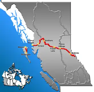 Highway 16 highlighted in red | ||||
| Route information | ||||
| Length | 1,173 km (729 mi) | |||
| Existed | 1941–present | |||
| Haida Gwaii segment | ||||
| Length | 101 km (63 mi) | |||
| North end | Masset | |||
| South end |  BC Ferries dock in Skidegate | |||
| Mainland segment | ||||
| Length | 1,072 km (666 mi) | |||
| West end | BC Ferries dock in Prince Rupert | |||
| Major intersections |  Hwy 113 in Terrace  Hwy 37 south in Terrace Hwy 37 north in Kitwanga  Hwy 118 in Topley  Hwy 35 in Burns Lake  Hwy 27 near Vanderhoof  Hwy 97 in Prince George | |||
| East end | Alberta border continues as  Hwy 16 (TCH) | |||
| Location | ||||
| Country | Canada | |||
| Province | British Columbia | |||
| Highway system | ||||
|
| ||||
| ||||

Highway 16 is a highway in British Columbia, Canada. It is a section of the Yellowhead Highway, a part of the Trans-Canada Highway that travels across Western Canada. The highway almost follows the path of the northern British Columbia alignment of the Canadian National Railway.