Bougainville Island
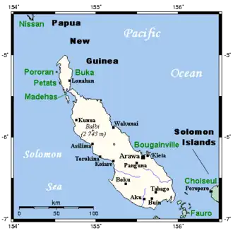 Bougainville and neighbouring islands | |
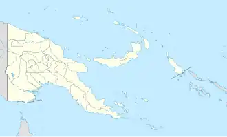  Bougainville Bougainville Island (Papua New Guinea) | |
| Etymology | Named for Louis Antoine de Bougainville |
|---|---|
| Geography | |
| Location | Melanesia |
| Coordinates | 6°14′40″S 155°23′02″E / 6.24444°S 155.38389°E |
| Archipelago | Solomon Islands |
| Area | 9,318 km2 (3,598 sq mi) |
| Highest elevation | 2,715 m (8907 ft) |
| Highest point | Mount Balbi |
| Administration | |
 Papua New Guinea | |
| Province | Autonomous Region of Bougainville |
| Demographics | |
| Population | ~249,000[1][2][3] (Buka Island included) |
| Pop. density | 32.19/km2 (83.37/sq mi) |
| Additional information | |
| Time zone |
|
Bougainville Island (/ˈbuːɡənvɪl/ (ⓘ), /ˈboʊɡənvɪl/ (ⓘ);[4] Tok Pisin: Bogenvil)[5] is the main island of the Autonomous Region of Bougainville, which is part of Papua New Guinea. Its land area is 9,300 km2 (3,600 sq mi). The highest point is Mount Balbi, on the main island, at 2,715 m (8,907 ft).
Bougainville is the largest island in the Solomon Islands archipelago. In a 2019 referendum, the citizens of Bougainville voted to become independent from Papua New Guinea by 2027.[6][7]
References
- ↑ "North Bougainville". citypopulation.de. 2011. Retrieved June 29, 2025.
- ↑ "Central Bougainville". citypopulation.de. 2011. Retrieved June 29, 2025.
- ↑ "South Bougainville". citypopulation.de. 2011. Retrieved June 29, 2025.
- ↑ "Bougainville". Dictionary.com Unabridged. Random House.
- ↑ "Bogenvil". Tok Pisin English Dictionary. Archived from the original on 25 June 2021. Retrieved 4 December 2019.
- ↑ "Bougainville referendum not binding - PM". Radio New Zealand. 11 March 2019. Retrieved 18 March 2019.
- ↑ Lyons, Kate (2019-12-11). "Bougainville referendum: region votes overwhelmingly for independence from Papua New Guinea". The Guardian. ISSN 0261-3077. Retrieved 2024-10-17.